Geolocate

Charleston topographic map

Click on the map to display elevation.

About this map

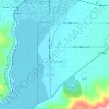
Name: Charleston topographic map, elevation, terrain.

Location: Charleston, Wasatch County, Utah, United States (40.45223 -111.47661 40.48472 -111.43353)

Average elevation: 5,528 ft

Minimum elevation: 5,384 ft

Maximum elevation: 6,644 ft

Wasatch County trails, hiking, mountain biking, running and outdoor activities

Other topographic maps

Click on a map to view its topography, its elevation and its terrain.

Heber City

United States > Utah > Wasatch County > Heber > Heber City

Average elevation: 5,771 ft

Soapstone Mountain

United States > Utah > Wasatch County

Average elevation: 8,924 ft

Silver Lake

United States > Utah > Wasatch County

Average elevation: 9,491 ft

Phosphate Hill

United States > Utah > Wasatch County

Average elevation: 6,309 ft

Jordanelle

United States > Utah > Wasatch County

Average elevation: 6,447 ft

Gear up for your next adventure:

Backpacking Tents - Weight-optimized shelters for multi-day topographic surveys
🥩Freeze-Dried Meals - Nutritious and lightweight food for remote expeditions
📱Solar Portable Charger - Solar power bank for charging devices off‑grid
🗃️Trail First Aid Kit - Essential kit for outdoor injuries and emergencies
🧴Hand Sanitizer - Keep hands clean while hiking

As an Amazon Associate, this site earns from qualifying purchases at no extra cost to you.