
Make a donation
Gear up for your next adventure:
As an Amazon Associate, this site earns from qualifying purchases at no extra cost to you.
Phosphate Hill topographic map
Click on the map to display elevation.
Make a donation
Gear up for your next adventure:
As an Amazon Associate, this site earns from qualifying purchases at no extra cost to you.
About this map
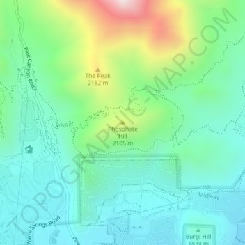
Name: Phosphate Hill topographic map, elevation, terrain.
Location: Phosphate Hill, Wasatch County, Utah, 84049, United States (40.54768 -111.47580 40.54778 -111.47570)
Average elevation: 6,309 ft
Minimum elevation: 5,640 ft
Maximum elevation: 8,179 ft
Wasatch County trails, hiking, mountain biking, running and outdoor activities
Make a donation
Gear up for your next adventure:
As an Amazon Associate, this site earns from qualifying purchases at no extra cost to you.
Other topographic maps
Click on a map to view its topography, its elevation and its terrain.
Make a donation
Gear up for your next adventure:
As an Amazon Associate, this site earns from qualifying purchases at no extra cost to you.