Geolocate

Rudy topographic map

Click on the map to display elevation.

About this map

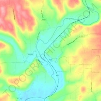
Name: Rudy topographic map, elevation, terrain.

Location: Rudy, Crawford County, Arkansas, 72952, United States (35.52097 -94.27396 35.54302 -94.21538)

Average elevation: 643 ft

Minimum elevation: 456 ft

Maximum elevation: 879 ft

Crawford County trails, hiking, mountain biking, running and outdoor activities

Other topographic maps

Click on a map to view its topography, its elevation and its terrain.

Artist Point

United States > Arkansas > Crawford County

Average elevation: 1,467 ft

Barcelona

United States > Arkansas > Crawford County

Average elevation: 774 ft

Uniontown

United States > Arkansas > Crawford County

Average elevation: 850 ft

Dora

United States > Arkansas > Crawford County

Average elevation: 531 ft

Alma

United States > Arkansas > Crawford County

Average elevation: 554 ft

Lee Creek

United States > Arkansas > Crawford County

Average elevation: 928 ft

Dyer

United States > Arkansas > Crawford County

Average elevation: 459 ft

Gear up for your next adventure:

🔭Stargazing Telescopes - Perfect for camping in low-light pollution areas shown on maps
🛡️Insect Repellent - Protection against bugs during outdoor activities
🩹Survival Bandages - High‑quality bandages for emergencies
🧦Merino Wool Socks - Moisture-wicking, blister-preventing socks for long treks
🧭Pro Hiking Compasses - High-accuracy liquid-filled compasses for topographic orientation

As an Amazon Associate, this site earns from qualifying purchases at no extra cost to you.