
Balcones Heights topographic map
Click on the map to display elevation.
About this map
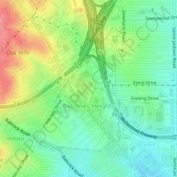
Name: Balcones Heights topographic map, elevation, terrain.
Location: Balcones Heights, Bexar County, Texas, United States (29.48262 -98.55944 29.50178 -98.54401)
Average elevation: 863 ft
Minimum elevation: 764 ft
Maximum elevation: 1,024 ft
Bexar County trails, hiking, mountain biking, running and outdoor activities
Other topographic maps
Click on a map to view its topography, its elevation and its terrain.