
Atascosa topographic map
Click on the map to display elevation.
About this map
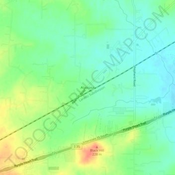
Name: Atascosa topographic map, elevation, terrain.
Location: Atascosa, Bexar County, Texas, 78002, United States (29.24690 -98.75197 29.28690 -98.71197)
Average elevation: 666 ft
Minimum elevation: 610 ft
Maximum elevation: 761 ft
Bexar County trails, hiking, mountain biking, running and outdoor activities
Other topographic maps
Click on a map to view its topography, its elevation and its terrain.
Shavano Park
United States > Texas > Bexar County
Despite lying in the far southeastern reaches of the Texas Hill Country, Shavano Park's terrain is flat to gently rolling. Most of the city is between 950 and 1,000 feet above sea level, which contrasts sharply with neighborhoods just north of Anderson Loop, where hills can rise 200 feet in a short distance.…
Average elevation: 961 ft
Government Canyon State Natural Area
United States > Texas > Bexar County > San Antonio
Average elevation: 1,171 ft