Geolocate

Midland topographic map

Click on the map to display elevation.

About this map

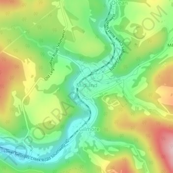
Name: Midland topographic map, elevation, terrain.

Location: Midland, Allegany County, Maryland, 21542, United States (39.58564 -78.95347 39.59322 -78.94220)

Average elevation: 1,870 ft

Minimum elevation: 1,575 ft

Maximum elevation: 2,290 ft

Allegany County trails, hiking, mountain biking, running and outdoor activities

Other topographic maps

Click on a map to view its topography, its elevation and its terrain.

La Vale

United States > Maryland > Allegany County

Average elevation: 1,030 ft

Pinto

United States > Maryland > Allegany County > Bel Air

Average elevation: 810 ft

North Branch

United States > Maryland > Allegany County

Average elevation: 791 ft

Woodland

United States > Maryland > Allegany County

Average elevation: 1,962 ft

Zihlman

United States > Maryland > Allegany County

Zihlman is located along Maryland Route 36, 1.5 miles (2.4 km) northeast of and 500 feet (150 m) lower in elevation than Frostburg. Mount Savage is 3 miles (5 km) further northeast along MD 36.

Average elevation: 1,936 ft

Amcelle

United States > Maryland > Allegany County > Potomac Park

Average elevation: 955 ft

McKenzie

United States > Maryland > Allegany County

Average elevation: 915 ft

Vale Summit

United States > Maryland > Allegany County

Average elevation: 2,149 ft

Spring Gap

United States > Maryland > Allegany County

Average elevation: 715 ft

Pleasant Grove

United States > Maryland > Allegany County

Average elevation: 1,047 ft

Potomac Park

United States > Maryland > Allegany County

Average elevation: 948 ft

Ocean

United States > Maryland > Allegany County

Average elevation: 1,946 ft

Oldtown

United States > Maryland > Allegany County

Average elevation: 636 ft

Nikep

United States > Maryland > Allegany County

Average elevation: 1,841 ft

National

United States > Maryland > Allegany County

Average elevation: 1,949 ft

Moscow

United States > Maryland > Allegany County

Average elevation: 1,785 ft

Midlothian

United States > Maryland > Allegany County

Average elevation: 2,093 ft

McCoole

United States > Maryland > Allegany County

Average elevation: 945 ft

Grahamtown

United States > Maryland > Allegany County

Average elevation: 1,972 ft

Klondike

United States > Maryland > Allegany County

Average elevation: 2,060 ft

Gilmore

United States > Maryland > Allegany County

Average elevation: 1,972 ft

Franklin

United States > Maryland > Allegany County

Average elevation: 1,486 ft

Detmold

United States > Maryland > Allegany County

Average elevation: 1,893 ft

Eckhart Mines

United States > Maryland > Allegany County

Average elevation: 1,880 ft

Ellerslie

United States > Maryland > Allegany County

Average elevation: 1,079 ft

Dawson

United States > Maryland > Allegany County

Average elevation: 1,063 ft

Corriganville

United States > Maryland > Allegany County

Average elevation: 1,073 ft

Cresaptown

United States > Maryland > Allegany County

Average elevation: 846 ft

Danville

United States > Maryland > Allegany County

Average elevation: 1,168 ft

Clarysville

United States > Maryland > Allegany County

Average elevation: 1,946 ft

Carlos

United States > Maryland > Allegany County

Average elevation: 2,083 ft

Bowling Green

United States > Maryland > Allegany County

Average elevation: 984 ft

Bowmans Addition

United States > Maryland > Allegany County

Average elevation: 1,132 ft

Bier

United States > Maryland > Allegany County

Average elevation: 938 ft

Bel Air

United States > Maryland > Allegany County

Average elevation: 863 ft

Barrelville

United States > Maryland > Allegany County

Average elevation: 1,437 ft

Little Orleans

United States > Maryland > Allegany County

Average elevation: 633 ft

Flintstone

United States > Maryland > Allegany County

Average elevation: 965 ft

Mount Savage

United States > Maryland > Allegany County

A small blue-collar community, Mount Savage lies at the base of Big Savage Mountain in the Allegheny Mountains, between the cities of Frostburg and Cumberland. It began as a small farming settlement in the mid-19th century, but it was not until 1844 that the region was put on the nation's map with the pressing…

Average elevation: 1,562 ft

Mexico

United States > Maryland > Allegany County

Average elevation: 735 ft

Rawlings

United States > Maryland > Allegany County

Average elevation: 965 ft

Jackson Mountain

United States > Maryland > Allegany County

Average elevation: 1,886 ft

Gear up for your next adventure:

🧢Outdoor Hiking Hat - Sun protection hat for outdoor explorers
🦟Ultrasonic Repellers - Create a bug-free zone at your camp or rest stop
🎁Geography Themed Gifts - Unique gift ideas for map lovers and geography enthusiasts
👖Convertible Hiking Pants - Versatile zip-off pants for changing altitudes and temperatures
🛡️Insect Repellent - Protection against bugs during outdoor activities

As an Amazon Associate, this site earns from qualifying purchases at no extra cost to you.