
McCoole topographic map
Click on the map to display elevation.
About this map
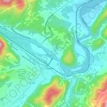
Name: McCoole topographic map, elevation, terrain.
Location: McCoole, Allegany County, Maryland, 26726, United States (39.42648 -78.99225 39.46648 -78.95225)
Average elevation: 945 ft
Minimum elevation: 732 ft
Maximum elevation: 1,637 ft
Allegany County trails, hiking, mountain biking, running and outdoor activities
Other topographic maps
Click on a map to view its topography, its elevation and its terrain.
Shaft
United States > Maryland > Allegany County > Borden Shaft > Braddock Estates
Shaft is a census-designated place (CDP) corresponding to the unincorporated community of Borden Shaft in Allegany County, Maryland, United States. As of the 2010 census, the CDP had a population of 235. It is located south of Frostburg, in the Georges Creek Valley. It lies at an elevation of 1,795 feet (547…
Average elevation: 1,929 ft
Lavale Community Park
United States > Maryland > Allegany County > Allegany Grove
Average elevation: 1,161 ft
Rawlings
United States > Maryland > Allegany County > Rawlings > Rawlings Heights
Average elevation: 860 ft
County Fairgrounds
United States > Maryland > Allegany County > Potomac Park > Cedar Cliff
Average elevation: 899 ft