
Make a donation
Gear up for your next adventure:
As an Amazon Associate, this site earns from qualifying purchases at no extra cost to you.
Richmond topographic map
Click on the map to display elevation.
Make a donation
Gear up for your next adventure:
As an Amazon Associate, this site earns from qualifying purchases at no extra cost to you.
Richmond
According to the United States Census Bureau, the town has a total area of 37.7 square miles (97.7 km2), of which 37.5 square miles (97.2 km2) are land and 0.19 square miles (0.5 km2) are water, comprising 0.52% of the town. Little Monadnock Mountain, elevation 1,883 feet (574 m) above sea level, is within a mile of the eastern boundary, in the town of Fitzwilliam. The highest point in Richmond is one mile northwest of Little Monadnock, on an unnamed hill whose elevation is 1,624 feet (495 m) above sea level. The Franconia Mountain Range (not to be confused with the much higher ridge in the White Mountains to the north) is a 1,300-foot-high (400 m) chain of hills in the western part of town.
Make a donation
Gear up for your next adventure:
As an Amazon Associate, this site earns from qualifying purchases at no extra cost to you.
About this map
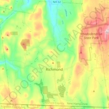
Name: Richmond topographic map, elevation, terrain.
Location: Richmond, Cheshire County, New Hampshire, United States (42.71971 -72.33971 42.81701 -72.20371)
Average elevation: 1,053 ft
Minimum elevation: 515 ft
Maximum elevation: 1,854 ft
Cheshire County trails, hiking, mountain biking, running and outdoor activities
Make a donation
Gear up for your next adventure:
As an Amazon Associate, this site earns from qualifying purchases at no extra cost to you.
Other topographic maps
Click on a map to view its topography, its elevation and its terrain.
West Chesterfield
United States > New Hampshire > Cheshire County > Chesterfield
Average elevation: 551 ft
Camp Notre Dame
United States > New Hampshire > Cheshire County > Chesterfield
Average elevation: 732 ft
Make a donation
Gear up for your next adventure:
As an Amazon Associate, this site earns from qualifying purchases at no extra cost to you.
Make a donation
Gear up for your next adventure:
As an Amazon Associate, this site earns from qualifying purchases at no extra cost to you.
Make a donation
Gear up for your next adventure:
As an Amazon Associate, this site earns from qualifying purchases at no extra cost to you.
Scotland
United States > New Hampshire > Cheshire County > Winchester > Scotland
Average elevation: 686 ft
Alstead Center
United States > New Hampshire > Cheshire County > Alstead > Alstead Center
Average elevation: 1,217 ft
Make a donation
Gear up for your next adventure:
As an Amazon Associate, this site earns from qualifying purchases at no extra cost to you.
Longmeadow Subdivision
United States > New Hampshire > Cheshire County > Keene
Average elevation: 587 ft