
L'Aquila topographic map
Interactive map
Click on the map to display elevation.
About this map
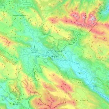
Name: L'Aquila topographic map, elevation, terrain.
Location: L'Aquila, Abruzzo, Italy (42.17658 13.17723 42.53155 13.65410)
Average elevation: 3,911 ft
Minimum elevation: 1,673 ft
Maximum elevation: 9,331 ft
Close to the highest of the Apennine summits, L'Aquila is positioned at an elevation of 721 metres (2,365 ft) in the Valley of the Aterno-Pescara, situated between four mountain peaks above 2,000 metres (6,600 ft).
Other topographic maps
Click on a map to view its topography, its elevation and its terrain.
Borgo San Lorenzo
Borgo San Lorenzo, Fossa, L'Aquila, Abruzzo, 67040, Italy
Average elevation: 1,991 ft
Rocca di Mezzo
Rocca di Mezzo, L'Aquila, Abruzzo, Italy
Average elevation: 4,442 ft
Castelvecchio Calvisio
Castelvecchio Calvisio, L'Aquila, Abruzzo, Italy
Average elevation: 4,229 ft
Castel di Ieri
Castel di Ieri, L'Aquila, Abruzzo, Italy
Average elevation: 2,516 ft
Villa Santa Lucia degli Abruzzi
Villa Santa Lucia degli Abruzzi, L'Aquila, Abruzzo, Italy
Average elevation: 3,602 ft
Pescocostanzo
Pescocostanzo, L'Aquila, Abruzzo, 67033, Italy
Average elevation: 4,751 ft