
Make a donation
Gear up for your next adventure:
As an Amazon Associate, this site earns from qualifying purchases at no extra cost to you.
Central Saanich topographic map
Click on the map to display elevation.
Make a donation
Gear up for your next adventure:
As an Amazon Associate, this site earns from qualifying purchases at no extra cost to you.
About this map
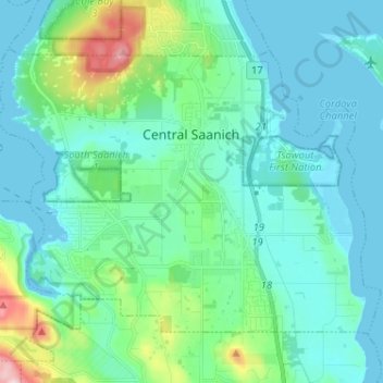
Name: Central Saanich topographic map, elevation, terrain.
Average elevation: 190 ft
Minimum elevation: 0 ft
Maximum elevation: 1,093 ft
Make a donation
Gear up for your next adventure:
As an Amazon Associate, this site earns from qualifying purchases at no extra cost to you.
Other topographic maps
Click on a map to view its topography, its elevation and its terrain.
Arden Islet
Canada > British Columbia > Capital Regional District > Juan de Fuca Electoral Area
Average elevation: 164 ft
San Juan Ridge
Canada > British Columbia > Capital Regional District > Juan de Fuca Electoral Area
Average elevation: 2,759 ft
Shirley
Canada > British Columbia > Capital Regional District > Juan de Fuca Electoral Area
Average elevation: 259 ft
Make a donation
Gear up for your next adventure:
As an Amazon Associate, this site earns from qualifying purchases at no extra cost to you.
Galiano
Canada > British Columbia > Capital Regional District > Southern Gulf Islands Electoral Area
Average elevation: 269 ft
Port Renfrew
Canada > British Columbia > Capital Regional District > Juan de Fuca Electoral Area > Port Renfrew
Average elevation: 256 ft
Ganges
Canada > British Columbia > Capital Regional District > Salt Spring Island Electoral Area > Ganges
Average elevation: 371 ft
Make a donation
Gear up for your next adventure:
As an Amazon Associate, this site earns from qualifying purchases at no extra cost to you.