
Make a donation
Gear up for your next adventure:
As an Amazon Associate, this site earns from qualifying purchases at no extra cost to you.
Verona topographic map
Click on the map to display elevation.
Make a donation
Gear up for your next adventure:
As an Amazon Associate, this site earns from qualifying purchases at no extra cost to you.
Verona
Verona has a humid continental climate (Dfa), with warm/hot humid summers and moderately cold winters. The climate is slightly cooler overall than in New York City, especially at night, because there is no urban heat island effect, as well as higher elevation and a more interior location (greater distance away from the moderating effects of the Atlantic Ocean).
Make a donation
Gear up for your next adventure:
As an Amazon Associate, this site earns from qualifying purchases at no extra cost to you.
About this map
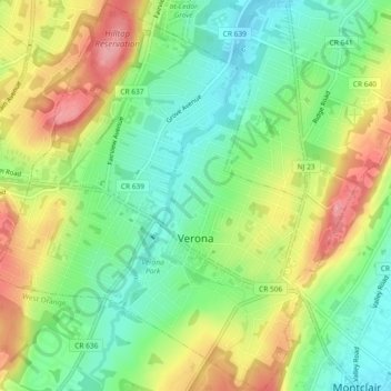
Name: Verona topographic map, elevation, terrain.
Location: Verona, Essex County, New Jersey, 07044, United States (40.81610 -74.26390 40.85086 -74.22099)
Average elevation: 463 ft
Minimum elevation: 299 ft
Maximum elevation: 692 ft
Essex County trails, hiking, mountain biking, running and outdoor activities
Make a donation
Gear up for your next adventure:
As an Amazon Associate, this site earns from qualifying purchases at no extra cost to you.
Other topographic maps
Click on a map to view its topography, its elevation and its terrain.
Eagle Rock Reservation
United States > New Jersey > Essex County > West Orange
Average elevation: 472 ft
Make a donation
Gear up for your next adventure:
As an Amazon Associate, this site earns from qualifying purchases at no extra cost to you.
Mills Reservation
United States > New Jersey > Essex County > Montclair > Montclair Heights
Average elevation: 397 ft
Make a donation
Gear up for your next adventure:
As an Amazon Associate, this site earns from qualifying purchases at no extra cost to you.
Cedar Grove
United States > New Jersey > Essex County > Cedar Grove
The township is located between the First and Second Watchung Mountains. The center of the township is in a valley that is about 280 feet (85 m) above sea level; however, many sections of Cedar Grove are well above 400 feet (120 m), including the Park Ridge Estates, the abandoned Essex County Hospital Center,…
Average elevation: 354 ft
Make a donation
Gear up for your next adventure:
As an Amazon Associate, this site earns from qualifying purchases at no extra cost to you.