
Make a donation
Gear up for your next adventure:
As an Amazon Associate, this site earns from qualifying purchases at no extra cost to you.
Albireh topographic map
Click on the map to display elevation.
Make a donation
Gear up for your next adventure:
As an Amazon Associate, this site earns from qualifying purchases at no extra cost to you.
About this map
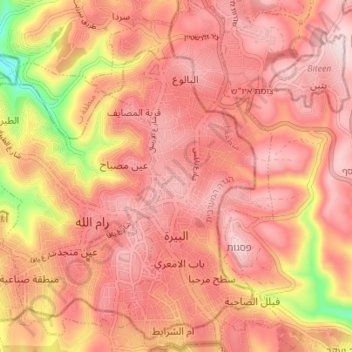
Name: Albireh topographic map, elevation, terrain.
Location: Albireh, Area A, West Bank, 611, Palestinian Territory (31.88128 35.19489 31.94003 35.23273)
Average elevation: 2,661 ft
Minimum elevation: 1,860 ft
Maximum elevation: 3,002 ft
Make a donation
Gear up for your next adventure:
As an Amazon Associate, this site earns from qualifying purchases at no extra cost to you.
Other topographic maps
Click on a map to view its topography, its elevation and its terrain.
Beit Jala
Palestinian Territory > Area A
Beit Jala (Arabic: بيت جالا) is a Palestinian Christian town in the Bethlehem Governorate of Palestine, in the West Bank. Beit Jala is located 10 km (6.2 mi)10 km south of Jerusalem, on the western side of the Hebron road, opposite Bethlehem, at 825 meters (2,707 ft) altitude. In 2017, Beit Jala had…
Average elevation: 2,470 ft
Meithalun
Palestinian Territory > Area A
The town is situated along the western edge of Marj Sanur, a valley and seasonal lake. It is the largest locality, of seven total, bordering Marj Sanur and controls the largest share of its fertile lands. It has an average elevation of 385 meters above sea level and is not elevated from its immediate…
Average elevation: 1,322 ft
Make a donation
Gear up for your next adventure:
As an Amazon Associate, this site earns from qualifying purchases at no extra cost to you.
Make a donation
Gear up for your next adventure:
As an Amazon Associate, this site earns from qualifying purchases at no extra cost to you.
Qabatiya
Palestinian Territory > Area A
Its entire land area is 50,547 dunams (50.5 km2; 19.5 sq mi), and its elevation is roughly 256 meters (840 feet). Qabatiya is famous for its olive groves, modern agriculture, and limestone industry.
Average elevation: 1,093 ft
Make a donation
Gear up for your next adventure:
As an Amazon Associate, this site earns from qualifying purchases at no extra cost to you.
Make a donation
Gear up for your next adventure:
As an Amazon Associate, this site earns from qualifying purchases at no extra cost to you.