Geolocate

Rimini topographic map

Click on the map to display elevation.

About this map

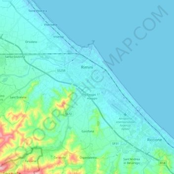
Name: Rimini topographic map, elevation, terrain.

Location: Rimini, Emilia-Romagna, 47921-47924, Italy (43.96968 12.43849 44.11579 12.63289)

Average elevation: 85 ft

Minimum elevation: -10 ft

Maximum elevation: 692 ft

Other topographic maps

Click on a map to view its topography, its elevation and its terrain.

Mulino Carlotti

Italy > Emilia-Romagna > Rimini > Rimini > Orsoleto

Average elevation: 30 ft

Perticara

Italy > Emilia-Romagna > Rimini

Average elevation: 1,775 ft

Torre Pedrera

Italy > Emilia-Romagna > Rimini > Rimini

Average elevation: 13 ft

Monte della Perticara

Italy > Emilia-Romagna > Rimini > Novafeltria

Average elevation: 1,932 ft

Cerasolo Ausa

Italy > Emilia-Romagna > Rimini > Cerasolo

Average elevation: 249 ft

Colombare

Italy > Emilia-Romagna > Rimini > Gemmiano

Average elevation: 449 ft

Maciano

Italy > Emilia-Romagna > Rimini

Average elevation: 1,558 ft

Gear up for your next adventure:

🌧️Backpack Rain Cover - Keep gear dry in wet weather
⛑️Personal Locator Beacon - Safety beacon for emergencies
🛌Ultralight Sleeping Bags - Compact down bags for cold nights in the wilderness
🪑Ultralight Camp Chairs - Portable seating for resting after a long day of mapping
🥩Freeze-Dried Meals - Nutritious and lightweight food for remote expeditions

As an Amazon Associate, this site earns from qualifying purchases at no extra cost to you.