
Crescent topographic map
Click on the map to display elevation.
About this map
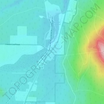
Name: Crescent topographic map, elevation, terrain.
Location: Crescent, Klamath County, Oregon, United States (43.44229 -121.71520 43.48229 -121.67520)
Average elevation: 4,557 ft
Minimum elevation: 4,419 ft
Maximum elevation: 5,187 ft
Klamath County trails, hiking, mountain biking, running and outdoor activities
Other topographic maps
Click on a map to view its topography, its elevation and its terrain.
Merrill
United States > Oregon > Klamath County
Merrill is at an elevation of 4,071 feet (1,241 m) in southern Klamath County, near the Oregon–California border. It is along Oregon Route 39 southeast of Klamath Falls and northwest of Tulelake. Lower Klamath Lake and Tule Lake, both in California, are slightly south of Merrill. By highway, the city is 20…
Average elevation: 4,072 ft
Malin
United States > Oregon > Klamath County
Malin is at an elevation of 4,062 feet (1,238 m) in southern Klamath County near the Oregon–California border. It is along a spur of Oregon Route 39, southeast of Klamath Falls, east of Merrill, and northeast of Tulelake. Lava Beds National Monument is to the south, nearby in California. By highway, the city…
Average elevation: 4,072 ft