
Make a donation
Gear up for your next adventure:
As an Amazon Associate, this site earns from qualifying purchases at no extra cost to you.
Huantsan topographic map
Click on the map to display elevation.
Make a donation
Gear up for your next adventure:
As an Amazon Associate, this site earns from qualifying purchases at no extra cost to you.
Huantsan
El nevado Huantsán es una montaña del Perú. Es la tercera cumbre más alta de la Cordillera Blanca y la cuarta del departamento de Áncash. Está situada 24 km al este de la ciudad de Huaraz. Tiene una altitud de 6370 m.
Make a donation
Gear up for your next adventure:
As an Amazon Associate, this site earns from qualifying purchases at no extra cost to you.
About this map
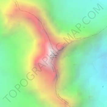
Name: Huantsan topographic map, elevation, terrain.
Location: Huantsan, Huaraz, Áncash, Perú (-9.51482 -77.31062 -9.51472 -77.31052)
Average elevation: 17,700 ft
Minimum elevation: 15,374 ft
Maximum elevation: 20,902 ft
Make a donation
Gear up for your next adventure:
As an Amazon Associate, this site earns from qualifying purchases at no extra cost to you.
Other topographic maps
Click on a map to view its topography, its elevation and its terrain.