
Make a donation
Gear up for your next adventure:
As an Amazon Associate, this site earns from qualifying purchases at no extra cost to you.
Heigenbrücken topographic map
Click on the map to display elevation.
Make a donation
Gear up for your next adventure:
As an Amazon Associate, this site earns from qualifying purchases at no extra cost to you.
Heigenbrücken
Die Gemeinde liegt in der Region Bayerischer Untermain inmitten des Spessarts. Der topographisch höchste Punkt der Gemeinde befindet sich an der Steigkoppe mit 493 m ü. NN (Lage)50.05069.30813, der niedrigste liegt am Lohrbach südöstlich von Heigenbrücken auf 248 m ü. NN (Lage)50.014239.3981.
Make a donation
Gear up for your next adventure:
As an Amazon Associate, this site earns from qualifying purchases at no extra cost to you.
About this map
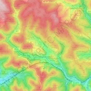
Name: Heigenbrücken topographic map, elevation, terrain.
Average elevation: 1,211 ft
Minimum elevation: 679 ft
Maximum elevation: 1,693 ft
Make a donation
Gear up for your next adventure:
As an Amazon Associate, this site earns from qualifying purchases at no extra cost to you.
Other topographic maps
Click on a map to view its topography, its elevation and its terrain.
Feldkahl
Deutschland > Bayern > Landkreis Aschaffenburg > Hösbach
Das Kirchdorf Feldkahl liegt im mittleren Kahlgrund am gleichnamigen Bach Feldkahl zwischen Rottenberg und Schimborn. Der topographisch höchste Punkt der Dorfgemarkung befindet sich an der Feldkahler Kapelle nordöstlich des Ortes am Klosterberg mit 332 m ü. NHN, der niedrigste liegt an der Feldkahl auf 193…
Average elevation: 797 ft
Kahl am Main
Deutschland > Bayern > Landkreis Aschaffenburg > Kahl am Main > Kahl am Main
Der Ort Kahl am Main liegt 107 Meter über dem Meeresspiegel. Es liegt an der Landesgrenze zu Hessen und verkehrsgünstig zwischen Aschaffenburg und Hanau (Main-Kinzig-Kreis). Der topographisch höchste Punkt der Gemeindegemarkung befindet sich nördlich von Kahl an der Birkenhainer Straße mit 130 m ü. NHN…
Average elevation: 367 ft
Schneppenbach
Deutschland > Bayern > Landkreis Aschaffenburg > Schneppenbach
Average elevation: 863 ft
Make a donation
Gear up for your next adventure:
As an Amazon Associate, this site earns from qualifying purchases at no extra cost to you.
Münchhof
Deutschland > Bayern > Landkreis Aschaffenburg > Hösbach > Wenighösbach
Average elevation: 709 ft
Winzenhohl
Deutschland > Bayern > Landkreis Aschaffenburg > Hösbach
Das Dorf Winzenhohl liegt auf 220 m ü. NN an der Kreisstraße 2 zwischen Hösbach-Bahnhof und Haibach am Winzenhohler Bach. Der topographisch höchste Punkt der Dorfgemarkung ist der Gipfel des Kellerberges westlich des Ortes mit 330 m ü. NN, der niedrigste Punkt liegt an der Aschaff auf 147 m ü. NN. Durch…
Average elevation: 748 ft
Oberwintersbach (Geishöhe)
Deutschland > Bayern > Landkreis Aschaffenburg > Dammbach
Oberwintersbach liegt auf dem 521 m ü. NHN hohen Berg Geishöhe, südlich von Wintersbach, direkt an der Grenze zum Landkreis Miltenberg. Im Westen fällt das Tal des Rosselbrunngrabens, mit dem Schloss Oberaulenbach, steil ab. Östlich befindet sich Oberkrausenbach. Im Südwesten und Südosten liegen…
Average elevation: 1,306 ft
Make a donation
Gear up for your next adventure:
As an Amazon Associate, this site earns from qualifying purchases at no extra cost to you.
Daxberg
Deutschland > Bayern > Landkreis Aschaffenburg
Das Dorf Daxberg liegt oberhalb des Kahlgrundes auf einer Höhe (gemessen an der Kirche) von 313 m ü. NN und hat eine Gemarkungsfläche von 271,69 Hektar (ca. 19 Hektar Wald und 253 Hektar Ackerfläche). Der topographisch höchste Punkt der Dorfgemarkung befindet sich am Gipfel des Glasberges, nördlich des…
Average elevation: 850 ft
Make a donation
Gear up for your next adventure:
As an Amazon Associate, this site earns from qualifying purchases at no extra cost to you.
Make a donation
Gear up for your next adventure:
As an Amazon Associate, this site earns from qualifying purchases at no extra cost to you.
Büttenberg
Deutschland > Bayern > Landkreis Aschaffenburg > Heinrichsthaler Forst
Average elevation: 1,243 ft
Großostheim
Deutschland > Bayern > Landkreis Aschaffenburg
Großostheim liegt am nordöstlichen Rand des Odenwalds in der Region Bayerischer Untermain. Durch den Hauptort sowie die Gemeindeteile Pflaumheim und Wenigumstadt fließt der Welzbach, der in Klein-Umstadt entspringt und über den Park Schönbusch in den Main mündet. Der topographisch höchste Punkt der…
Average elevation: 486 ft
Geiselbach
Deutschland > Bayern > Landkreis Aschaffenburg > Geiselbach > Geiselbach
Die Gemeinde liegt im Kahlgrund direkt an der bayerisch/hessischen Landesgrenze, 20 km nördlich von Aschaffenburg, 50 km östlich von Frankfurt am Main auf 272 m ü. NHN. Der topographisch höchste Punkt der Gemeinde befindet sich am Gipfel des Kreuzberges 388 m ü. NHN (Lage)50.13079.20179, der niedrigste…
Average elevation: 971 ft
Make a donation
Gear up for your next adventure:
As an Amazon Associate, this site earns from qualifying purchases at no extra cost to you.
Vormwald
Deutschland > Bayern > Landkreis Aschaffenburg > Sommerkahl > Vormwald
Average elevation: 1,083 ft
Make a donation
Gear up for your next adventure:
As an Amazon Associate, this site earns from qualifying purchases at no extra cost to you.