
Lively Island topographic map
Interactive map
Click on the map to display elevation.
About this map
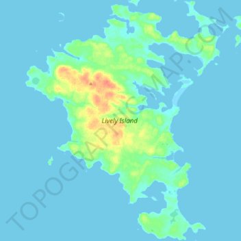
Name: Lively Island topographic map, elevation, terrain.
Location: Lively Island, Falkland Islands (-52.10297 -58.55443 -51.98757 -58.39214)
Average elevation: 16 ft
Minimum elevation: -3 ft
Maximum elevation: 128 ft
Other topographic maps
Click on a map to view its topography, its elevation and its terrain.
West Falkland
West Falkland, Islas Malvinas, Falkland Islands
Average elevation: 105 ft
Port Howard
Falkland Islands > Port Howard > Port Howard
Port Howard, Islas Malvinas, Falkland Islands
Average elevation: 148 ft