
Make a donation
Gear up for your next adventure:
As an Amazon Associate, this site earns from qualifying purchases at no extra cost to you.
Napoleon Hill topographic map
Click on the map to display elevation.
Make a donation
Gear up for your next adventure:
As an Amazon Associate, this site earns from qualifying purchases at no extra cost to you.
About this map
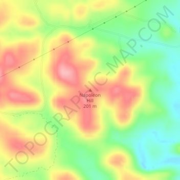
Name: Napoleon Hill topographic map, elevation, terrain.
Location: Napoleon Hill, Independence County, Arkansas, United States (35.89586 -91.69825 35.89596 -91.69815)
Average elevation: 531 ft
Minimum elevation: 338 ft
Maximum elevation: 722 ft
Independence County trails, hiking, mountain biking, running and outdoor activities
Make a donation
Gear up for your next adventure:
As an Amazon Associate, this site earns from qualifying purchases at no extra cost to you.
Other topographic maps
Click on a map to view its topography, its elevation and its terrain.
Southside
United States > Arkansas > Independence County
The elevation of Southside is 354 feet (108 m).
Average elevation: 367 ft
Make a donation
Gear up for your next adventure:
As an Amazon Associate, this site earns from qualifying purchases at no extra cost to you.