
Make a donation
Gear up for your next adventure:
As an Amazon Associate, this site earns from qualifying purchases at no extra cost to you.
Freyburg topographic map
Click on the map to display elevation.
Make a donation
Gear up for your next adventure:
As an Amazon Associate, this site earns from qualifying purchases at no extra cost to you.
About this map
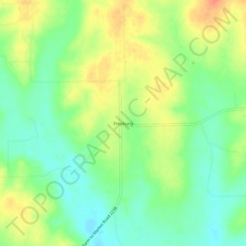
Name: Freyburg topographic map, elevation, terrain.
Location: Freyburg, Fayette County, Texas, United States (29.73773 -96.98665 29.77773 -96.94665)
Average elevation: 374 ft
Minimum elevation: 305 ft
Maximum elevation: 459 ft
Fayette County trails, hiking, mountain biking, running and outdoor activities
Make a donation
Gear up for your next adventure:
As an Amazon Associate, this site earns from qualifying purchases at no extra cost to you.
Other topographic maps
Click on a map to view its topography, its elevation and its terrain.
La Grange
United States > Texas > Fayette County
The center of La Grange has an elevation of 266 feet (81 m) above sea level.
Average elevation: 299 ft
Make a donation
Gear up for your next adventure:
As an Amazon Associate, this site earns from qualifying purchases at no extra cost to you.
La Grange
United States > Texas > Fayette County
The center of La Grange has an elevation of 266 feet (81 m) above sea level.
Average elevation: 299 ft