Geolocate

Rosebud topographic map

Click on the map to display elevation.

About this map

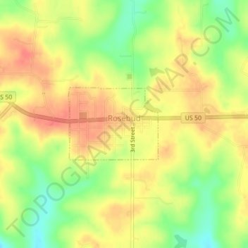
Name: Rosebud topographic map, elevation, terrain.

Location: Rosebud, Gasconade County, Missouri, United States (38.38269 -91.40876 38.39059 -91.39626)

Average elevation: 863 ft

Minimum elevation: 758 ft

Maximum elevation: 932 ft

Gasconade County trails, hiking, mountain biking, running and outdoor activities

Other topographic maps

Click on a map to view its topography, its elevation and its terrain.

Bay

United States > Missouri > Gasconade County

Average elevation: 633 ft

Hermann

United States > Missouri > Gasconade County > Hermann > Hermann

Average elevation: 597 ft

Gear up for your next adventure:

📱Heavy-Duty Phone Cases - Drop-proof and waterproof protection for outdoor navigation
🦶Carbon Trekking Poles - Reduce knee impact on steep descents with ultra-light poles
🗺️Topographic Maps - Detailed topo maps for hiking, exploring and outdoor navigation
🧼Biodegradable Camping Soap - Eco‑friendly soap for outdoor hygiene
🍳Camping Cook Set - Complete cookware for outdoor meals

As an Amazon Associate, this site earns from qualifying purchases at no extra cost to you.