Geolocate

Oro Valley topographic map

Interactive map

Click on the map to display elevation.

Oro Valley

Oro Valley is located at 32°25′N 110°59′W / 32.417°N 110.983°W / 32.417; -110.983 (32.4212, −110.9760) in the middle Cañada del Oro Valley. Oro Valley sits at an average elevation of 2,620 feet (800 m) above sea level.

Wikipedia (CC-BY-SA 3.0)

About this map

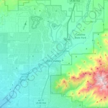
Name: Oro Valley topographic map, elevation, terrain.

Location: Oro Valley, Pima County, Arizona, United States (32.33664 -111.03007 32.48195 -110.92745)

Average elevation: 3,179 ft

Minimum elevation: 2,251 ft

Maximum elevation: 7,221 ft

Pima County trails, hiking, mountain biking, running and outdoor activities

Other topographic maps

Click on a map to view its topography, its elevation and its terrain.

Green Valley

United States > Arizona > Pima County > Sahuarita

Average elevation: 3,156 ft

Vail

United States > Arizona > Pima County > Vail

Average elevation: 3,396 ft

Windy Point

United States > Arizona > Pima County

Average elevation: 6,060 ft

Lizard Rock

United States > Arizona > Pima County

Average elevation: 6,696 ft

Corona de Tucson

United States > Arizona > Pima County

Average elevation: 3,369 ft

Continental

United States > Arizona > Pima County > Green Valley

Average elevation: 2,913 ft

Pascua Pueblo

United States > Arizona > Pima County

Average elevation: 2,602 ft

Vail

United States > Arizona > Pima County > Vail

Average elevation: 3,396 ft

Green Valley

United States > Arizona > Pima County

Average elevation: 2,999 ft

Ajo

United States > Arizona > Pima County

Average elevation: 1,795 ft

Corona de Tucson

United States > Arizona > Pima County

Average elevation: 3,369 ft

Ajo

United States > Arizona > Pima County > Ajo

Average elevation: 1,775 ft

Tucson

United States > Arizona > Pima County > Tucson

The city's elevation is 2,643 ft (806 m) above sea level (as measured at the Tucson International Airport). Tucson is on an alluvial plain in the Sonoran Desert, surrounded by five minor ranges of mountains: the Santa Catalina Mountains and the Tortolita Mountains to the north, the Santa Rita Mountains to the…

Average elevation: 2,743 ft

Green Valley

United States > Arizona > Pima County > Sahuarita

Average elevation: 3,156 ft

Pantano

United States > Arizona > Pima County

Average elevation: 3,612 ft

South Mountain

United States > Arizona > Pima County

Average elevation: 2,805 ft

Flowing Wells

United States > Arizona > Pima County

Average elevation: 2,254 ft

Sonoran Desert

United States > Arizona > Pima County

Average elevation: 1,696 ft

Newfield

United States > Arizona > Pima County

Average elevation: 2,687 ft

Sasabe

United States > Arizona > Pima County

Average elevation: 3,570 ft