Geolocate

Raven topographic map

Click on the map to display elevation.

About this map

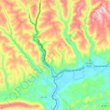
Name: Raven topographic map, elevation, terrain.

Location: Raven, Tazewell County, Virginia, United States (37.06562 -81.90015 37.13656 -81.81466)

Average elevation: 2,346 ft

Minimum elevation: 1,883 ft

Maximum elevation: 2,946 ft

Tazewell County trails, hiking, mountain biking, running and outdoor activities

Other topographic maps

Click on a map to view its topography, its elevation and its terrain.

Lake Witten

United States > Virginia > Tazewell County

Average elevation: 2,694 ft

Abbs Valley

United States > Virginia > Tazewell County

Average elevation: 2,769 ft

Pounding Mill

United States > Virginia > Tazewell County

Average elevation: 2,444 ft

Glen Burke

United States > Virginia > Tazewell County

Average elevation: 2,638 ft

Tiptop

United States > Virginia > Tazewell County

Average elevation: 2,835 ft

Stony Ridge

United States > Virginia > Tazewell County

Average elevation: 2,648 ft

Indian

United States > Virginia > Tazewell County > Cedar Bluff

Average elevation: 2,234 ft

Mud Fork

United States > Virginia > Tazewell County

Average elevation: 2,881 ft

Gear up for your next adventure:

🥘Titanium Cookware - Durable, featherlight pots and pans for backpacking
Camping Coffee Makers - Enjoy premium coffee at the summit or campsite
🧥Men's Rain Shells - Premium waterproof and breathable jackets for mountain weather
🦺Reflective Outdoor Gear - Safety gear for low‑light conditions
🔦Powerful Headlamps - Ultra-bright hands-free lighting for night navigation

As an Amazon Associate, this site earns from qualifying purchases at no extra cost to you.