Geolocate

Chunchula topographic map

Click on the map to display elevation.

About this map

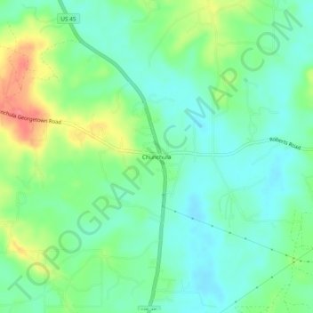
Name: Chunchula topographic map, elevation, terrain.

Location: Chunchula, Mobile County, Alabama, 36521, United States (30.90185 -88.22056 30.94185 -88.18056)

Average elevation: 118 ft

Minimum elevation: 43 ft

Maximum elevation: 272 ft

Mobile County trails, hiking, mountain biking, running and outdoor activities

Other topographic maps

Click on a map to view its topography, its elevation and its terrain.

Dauphin Island

United States > Alabama > Mobile County

Average elevation: 0 ft

Bayou La Batre

United States > Alabama > Mobile County

Average elevation: 30 ft

Citronelle

United States > Alabama > Mobile County

Average elevation: 226 ft

Mobile Bay

United States > Alabama > Mobile County

Average elevation: 39 ft

Grand Bay

United States > Alabama > Mobile County

Average elevation: 72 ft

Chickasaw

United States > Alabama > Mobile County

Average elevation: 20 ft

Satsuma

United States > Alabama > Mobile County

Average elevation: 23 ft

Creola

United States > Alabama > Mobile County

Average elevation: 36 ft

Mount Vernon

United States > Alabama > Mobile County

Average elevation: 59 ft

Spanish River

United States > Alabama > Mobile County > Mobile

Average elevation: 10 ft

Gear up for your next adventure:

🧦Merino Wool Socks - Moisture-wicking, blister-preventing socks for long treks
🧭Hiking Compass - Precision compass for reliable navigation in the wilderness
🎒Day Hiking Backpack - Lightweight backpack perfect for day trips and outdoor adventures
Solar GPS Watches - Advanced multisport watches with built-in topographic maps
🪶Camp Gear Gift Set - Perfect gift bundle for outdoor fans

As an Amazon Associate, this site earns from qualifying purchases at no extra cost to you.