Geolocate

County Concil topographic map

Click on the map to display elevation.

About this map

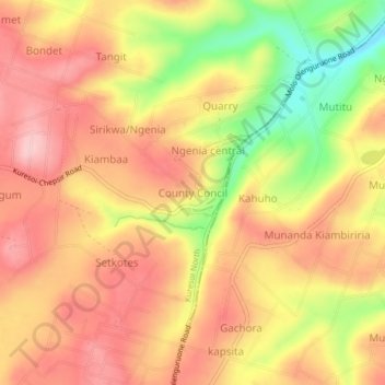
Name: County Concil topographic map, elevation, terrain.

Location: County Concil, Nakuru, Kenya (-0.31634 35.66582 -0.27634 35.70582)

Average elevation: 8,881 ft

Minimum elevation: 8,507 ft

Maximum elevation: 9,108 ft

Other topographic maps

Click on a map to view its topography, its elevation and its terrain.

Njoro

Kenya > Nakuru

Average elevation: 7,917 ft

Olkaria ward

Kenya > Nakuru > Naivasha

Average elevation: 6,388 ft

Lake Naivasha

Kenya > Nakuru > Lake Naivasha Simba Lodge

Average elevation: 6,220 ft

Gear up for your next adventure:

🧭Compass with Lanyard - Easy‑carry compass for navigation
🎒Trekking Poles - Sturdy poles for balance and stability on rough terrain
🏕️Family Camping Gear - Essentials for group camping trips
🧭GPS Watch Accessories - Bands and chargers for GPS watches
🛠️Backpacking Tool Kit - Essential toolkit for outdoor repairs

As an Amazon Associate, this site earns from qualifying purchases at no extra cost to you.