Make a donation
Gear up for your next adventure:
As an Amazon Associate, this site earns from qualifying purchases at no extra cost to you.
Njoro topographic map
Click on the map to display elevation.
Make a donation
Gear up for your next adventure:
As an Amazon Associate, this site earns from qualifying purchases at no extra cost to you.
About this map
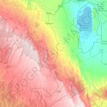
Name: Njoro topographic map, elevation, terrain.
Location: Njoro, Nakuru, Rift Valley, 20106, Kenya (-0.71296 35.84496 -0.27968 36.07754)
Average elevation: 7,917 ft
Minimum elevation: 5,755 ft
Maximum elevation: 10,075 ft
Make a donation
Gear up for your next adventure:
As an Amazon Associate, this site earns from qualifying purchases at no extra cost to you.
Other topographic maps
Click on a map to view its topography, its elevation and its terrain.
Make a donation
Gear up for your next adventure:
As an Amazon Associate, this site earns from qualifying purchases at no extra cost to you.
Nakuru
On 3 June 2021, Nakuru was officially endorsed for city status after the Kenyan Senate voted for its elevation from a Municipality. The President of the Republic of Kenya will need to give a city charter for official transformation to city status. If and once given the charter, Nakuru will be the fourth city…
Average elevation: 6,539 ft
Make a donation
Gear up for your next adventure:
As an Amazon Associate, this site earns from qualifying purchases at no extra cost to you.
Make a donation
Gear up for your next adventure:
As an Amazon Associate, this site earns from qualifying purchases at no extra cost to you.
