
Ghazir topographic map
Click on the map to display elevation.
Ghazir
Ghazir (Arabic: غزير) is a town and municipality in the Keserwan District of the Keserwan-Jbeil Governorate of Lebanon. It is located 27 kilometres (17 mi) north of Beirut. It has an average elevation of 380 meters above sea level and a total land area of 542 hectares (2.09 sq mi).
About this map
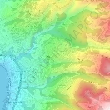
Name: Ghazir topographic map, elevation, terrain.
Average elevation: 1,178 ft
Minimum elevation: 0 ft
Maximum elevation: 3,054 ft
Other topographic maps
Click on a map to view its topography, its elevation and its terrain.
Kfardebian
Lebanon > Keserwan-Jbeil Governorate
Kfardebian (Arabic: كفر دبيان; also spelled Kfar Dibiane and also known as Moucha'a Keserwan) is a municipality in the Keserwan District of the Keserwan-Jbeil Governorate in Lebanon. It is located 45 kilometers north of Beirut. Its average elevation is 1,220 meters above sea level and its total land…
Average elevation: 5,768 ft
Ballouneh
Lebanon > Keserwan-Jbeil Governorate
Ballouneh (Arabic: بلونة) is a town and municipality in the Keserwan District of the Keserwan-Jbeil Governorate of Lebanon. It is located 18 kilometers north of Beirut. It has an approximate area of 3.93 square kilometers and an average elevation of 650 meters above sea level. Ballouneh's inhabitants are…
Average elevation: 2,133 ft