
Loma Linda topographic map
Interactive map
Click on the map to display elevation.
About this map
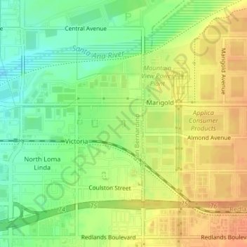
Name: Loma Linda topographic map, elevation, terrain.
Average elevation: 1,096 ft
Minimum elevation: 1,027 ft
Maximum elevation: 1,152 ft
San Bernardino County trails, hiking, mountain biking, running and outdoor activities
Other topographic maps
Click on a map to view its topography, its elevation and its terrain.
Big Bear Lake
United States > California > San Bernardino County > Big Bear Lake
At a surface elevation of 6,743 ft (2,055 m) above sea level, it has an east-west length of approximately seven miles (11 km) and is approximately 2.5 miles (4.0 km) at its widest measurement, though the lake's width mostly averages a little more than 1⁄2 mi (0.8 km). These approximations are based on the…
Average elevation: 7,247 ft
Piñon Hills
United States > California > San Bernardino County
Piñon Hills (from piñón, Spanish for 'pine nut') is a census-designated place in San Bernardino County, California, near the Los Angeles County line. It is located along Pearblossom Highway, 28 miles east of Palmdale, and 15 miles west of the Cajon Pass where Pearblossom Highway meets Interstate 15. The…
Average elevation: 3,973 ft
Oak Glen
United States > California > San Bernardino County
Oak Glen is a census-designated place situated between the San Bernardino Mountains and the Little San Bernardino Mountains in San Bernardino County, California, United States. Oak Glen is located 15 miles east of San Bernardino, at an elevation of 4,734 feet (1,443 m). The population was 638 at the 2010…
Average elevation: 4,928 ft
Golden Mesa
United States > California > San Bernardino County > Victorville
Average elevation: 2,910 ft
Sugarloaf
United States > California > San Bernardino County > Big Bear City
Average elevation: 7,067 ft
Badger Hill
United States > California > San Bernardino County > San Bernardino
Average elevation: 1,722 ft
Arrowhead Highlands
United States > California > San Bernardino County > Crestline
Average elevation: 4,610 ft
Cedar Glen
United States > California > San Bernardino County > Lake Arrowhead
Average elevation: 5,381 ft
Big Bear City
United States > California > San Bernardino County
It is estimated that the Serrano natives first settled in Big Bear between 1,500 and 2,000 years ago. The Serranos had both winter and summer settlements throughout the area. While their winter village was located in Lucerne Valley, they relocated to villages in the San Bernardino mountains during summer, as…
Average elevation: 7,110 ft
Eagle Ranch
United States > California > San Bernardino County > Victorville
Average elevation: 3,301 ft
North Fontana
United States > California > San Bernardino County > Fontana
Average elevation: 1,519 ft
Muscoy
United States > California > San Bernardino County > Rialto
Muscoy is located at 34°9′22″N 117°20′48″W / 34.15611°N 117.34667°W / 34.15611; -117.34667 (34.156009, -117.346552). Elevation ranges from 1240' in the south to 1600' in the north.
Average elevation: 1,421 ft
Sugarloaf
United States > California > San Bernardino County > Victorville
Average elevation: 2,769 ft
Santa Ana River Trail & Parkway
United States > California > San Bernardino County > San Bernardino
Average elevation: 1,017 ft
Running Springs
United States > California > San Bernardino County
Running Springs is a mountain community in the San Bernardino Mountains. It is an inholding in the San Bernardino National Forest. Situated at the junction of State Route 18 and State Route 330, it is a major gateway to the mountain communities of Lake Arrowhead, Arrowbear, Green Valley Lake, and Big Bear and…
Average elevation: 5,489 ft
Big Bear Lake
United States > California > San Bernardino County
Since 1970, Big Bear Lake has held its annual Oktoberfest. The Big Bear Lake Oktoberfest also sports the highest beer garden, by elevation, in the United States. Big Bear Lake was incorporated as a city on November 28, 1980.
Average elevation: 7,182 ft
Desert Knolls Manor
United States > California > San Bernardino County > Apple Valley
Average elevation: 3,045 ft
Sand to Snow National Monument
United States > California > San Bernardino County
Sand dunes are home to the endangered fringe-toed lizard at the lower elevation confluence of the Whitewater and San Gorgonio Rivers, while Desert bighorn sheep are found at higher elevations.
Average elevation: 4,669 ft
Fort Irwin
United States > California > San Bernardino County
Fort Irwin National Training Center (Fort Irwin NTC) is a major training area for the United States military in the Mojave Desert in northern San Bernardino County, California. Fort Irwin is at an average elevation of 2,454 feet (748 m). It is located 37 miles (60 km) northeast of Barstow, in the Calico…
Average elevation: 2,539 ft
Fredalba
United States > California > San Bernardino County > Running Springs
Average elevation: 5,075 ft
Grand Terrace
United States > California > San Bernardino County > Grand Terrace > Grand Terrace
This 3.6-square-mile (9.3 km2) community has an average elevation of 1,065 feet (325 m). Its motto, inscribed on the city flag, is "The Blue Mountain City" (its official slogan is "A city set upon a mountain cannot be hidden"), and refers to the Blue Lupine flower that used to grow on Blue Mountain in the…
Average elevation: 1,132 ft
Grapeland
United States > California > San Bernardino County > Rancho Cucamonga
Average elevation: 1,388 ft
Shadow Hills
United States > California > San Bernardino County > Adelanto
Average elevation: 2,785 ft
Serrano Village
United States > California > San Bernardino County > San Bernardino
Average elevation: 1,604 ft
Black Mountain Wilderness
United States > California > San Bernardino County
Average elevation: 2,825 ft
North Shore
United States > California > San Bernardino County > Lake Arrowhead
Average elevation: 5,200 ft
Etiwanda
United States > California > San Bernardino County > Rancho Cucamonga
Average elevation: 1,362 ft
Baldy Mesa
United States > California > San Bernardino County > Baldy Mesa
Average elevation: 3,494 ft
North Ontario
United States > California > San Bernardino County > Upland > North Ontario
Average elevation: 1,224 ft
Patton
United States > California > San Bernardino County > San Bernardino
Average elevation: 1,362 ft
High Country
United States > California > San Bernardino County > Hesperia
Average elevation: 3,622 ft
Rochester
United States > California > San Bernardino County > Rancho Cucamonga > Rochester
Average elevation: 1,125 ft