Geolocate

Mali topographic map

Click on the map to display elevation.

About this map

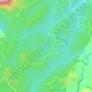
Name: Mali topographic map, elevation, terrain.

Location: Mali, Udumbanchola, Idukki, Kerala, India (9.72416 77.13397 9.74111 77.15368)

Average elevation: 3,583 ft

Minimum elevation: 3,340 ft

Maximum elevation: 4,147 ft

Other topographic maps

Click on a map to view its topography, its elevation and its terrain.

Pettimudi Hill Top

India > Kerala > Idukki

Average elevation: 2,657 ft

Muttukadu

India > Kerala > Idukki

Average elevation: 3,596 ft

Muthirapuzha

India > Kerala > Idukki

Average elevation: 1,808 ft

Idukki Dam

India > Kerala > Idukki

Average elevation: 2,300 ft

Silent vally thodu

India > Kerala > Idukki

Average elevation: 5,472 ft

Mattupetty Dam

India > Kerala > Idukki

Average elevation: 5,463 ft

Malankara Dam

India > Kerala > Idukki

Average elevation: 194 ft

Chokramudi

India > Kerala > Idukki

Average elevation: 5,479 ft

Gear up for your next adventure:

🏔️Mountain Trail Maps - High‑detail maps for popular peaks
🧣Hiking Neck Gaiter - Multi‑use neck protection for outdoor weather
🔋Solar Power Banks - Keep your GPS and phone charged in remote wilderness areas
🔦Powerful Headlamps - Ultra-bright hands-free lighting for night navigation
🥾Men's Hiking Boots - Durable, waterproof footwear for rugged terrain and steep inclines

As an Amazon Associate, this site earns from qualifying purchases at no extra cost to you.