
Pisgah Game Lands topographic map
Interactive map
Click on the map to display elevation.
About this map
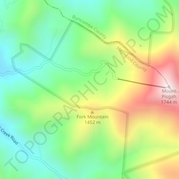
Name: Pisgah Game Lands topographic map, elevation, terrain.
Average elevation: 4,160 ft
Minimum elevation: 3,281 ft
Maximum elevation: 5,643 ft
Haywood County trails, hiking, mountain biking, running and outdoor activities
Other topographic maps
Click on a map to view its topography, its elevation and its terrain.
Town of Maggie Valley
United States > North Carolina > Haywood County > Town of Maggie Valley
Average elevation: 2,976 ft