Geolocate

Sheridan topographic map

Click on the map to display elevation.

About this map

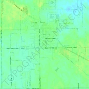
Name: Sheridan topographic map, elevation, terrain.

Location: Sheridan, Hamilton County, Indiana, United States (40.11435 -86.23762 40.14795 -86.19796)

Average elevation: 951 ft

Minimum elevation: 928 ft

Maximum elevation: 974 ft

Hamilton County trails, hiking, mountain biking, running and outdoor activities

Other topographic maps

Click on a map to view its topography, its elevation and its terrain.

Lake Windemere

United States > Indiana > Hamilton County > Carmel

Average elevation: 896 ft

Boxley

United States > Indiana > Hamilton County

Average elevation: 928 ft

Noblesville

United States > Indiana > Hamilton County

Average elevation: 791 ft

Carmel

United States > Indiana > Hamilton County > Carmel > Carmel

Average elevation: 833 ft

creek

United States > Indiana > Hamilton County > Westfield

Average elevation: 915 ft

Gear up for your next adventure:

🦶Hiking Gaiters - Keep debris and water out of your boots
🪄Magnetic Compass - Accurate compass for navigation
🧦Hiking Socks - Comfortable socks to prevent blisters on long hikes
🔌Solar Panel Charger - Charge gear sustainably outdoors
❄️Traction Cleats - Prevent slips on icy trails during winter hikes

As an Amazon Associate, this site earns from qualifying purchases at no extra cost to you.