
Make a donation
Gear up for your next adventure:
As an Amazon Associate, this site earns from qualifying purchases at no extra cost to you.
Chamonix-Mont-Blanc topographic map
Click on the map to display elevation.
Make a donation
Gear up for your next adventure:
As an Amazon Associate, this site earns from qualifying purchases at no extra cost to you.
Chamonix-Mont-Blanc
Due to its elevation, Chamonix has a humid continental climate (Dfb, according to the Köppen climate classification), with an average annual precipitation of 1,280 mm (50 in). Summers are mild and winters are cold and snowy.
Make a donation
Gear up for your next adventure:
As an Amazon Associate, this site earns from qualifying purchases at no extra cost to you.
About this map
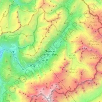
Name: Chamonix-Mont-Blanc topographic map, elevation, terrain.
Average elevation: 7,267 ft
Minimum elevation: 1,988 ft
Maximum elevation: 15,761 ft
Make a donation
Gear up for your next adventure:
As an Amazon Associate, this site earns from qualifying purchases at no extra cost to you.
Other topographic maps
Click on a map to view its topography, its elevation and its terrain.
Mer de Glace
France > Auvergne-Rhône-Alpes > Upper Savoy > Chamonix-Mont-Blanc
The glacier lies above the Chamonix valley. The pressure within the ice is known to reach at least 30 atmospheres. The Mer de Glace can be considered as originating at an elevation of 2,100 metres (6,900 ft), just north of the Aiguille du Tacul, where it is formed by the confluence of the Glacier de Leschaux…
Average elevation: 7,621 ft
Mont Blanc / Monte Bianco
France > Auvergne-Rhône-Alpes > Upper Savoy > Saint-Gervais-les-Bains
The climate is cold and temperate (Köppen climate classification Cfb), and is greatly influenced by altitude. Being the highest part of the Alps, Mont Blanc and surrounding mountains can create their own weather patterns. Temperatures drop as the mountains gain in height, and the summit of Mont Blanc is a…
Average elevation: 13,425 ft
Argentière
France > Auvergne-Rhône-Alpes > Upper Savoy > Chamonix-Mont-Blanc
Argentière (French pronunciation: [aʁʒɑ̃tjɛʁ]) is a picturesque skiing, alpine walking and mountaineering village in the French Alps, part of the commune of Chamonix-Mont-Blanc, at an altitude of 1,252 m (4,108 ft).
Average elevation: 5,492 ft
Mer de Glace
France > Auvergne-Rhône-Alpes > Upper Savoy > Chamonix-Mont-Blanc
The glacier lies above the Chamonix valley. The pressure within the ice is known to reach at least 30 atmospheres. The Mer de Glace can be considered as originating at an elevation of 2,100 metres (6,900 ft), just north of the Aiguille du Tacul [fr], where it is formed by the confluence of the Glacier de…
Average elevation: 7,618 ft
Make a donation
Gear up for your next adventure:
As an Amazon Associate, this site earns from qualifying purchases at no extra cost to you.
Les Frasserands
France > Auvergne-Rhône-Alpes > Upper Savoy > Chamonix-Mont-Blanc > Argentière
Average elevation: 5,591 ft
Mont Blanc / Monte Bianco
France > Auvergne-Rhône-Alpes > Upper Savoy > Saint-Gervais-les-Bains
The climate is cold and temperate (Köppen climate classification Cfb), and is greatly influenced by altitude. Being the highest part of the Alps, Mont Blanc and surrounding mountains can create their own weather patterns. Temperatures drop as the mountains gain in height, and the summit of Mont Blanc is a…
Average elevation: 13,425 ft
Make a donation
Gear up for your next adventure:
As an Amazon Associate, this site earns from qualifying purchases at no extra cost to you.
Mont Blanc / Monte Bianco
France > Auvergne-Rhône-Alpes > Upper Savoy > Saint-Gervais-les-Bains
The climate is cold and temperate (Köppen climate classification Cfb), and is greatly influenced by altitude. Being the highest part of the Alps, Mont Blanc and surrounding mountains can create their own weather patterns. Temperatures drop as the mountains gain in height, and the summit of Mont Blanc is a…
Average elevation: 13,425 ft
Essert-la-Pierre
France > Auvergne-Rhône-Alpes > Upper Savoy > Saint-Jean-d'Aulps
Average elevation: 3,921 ft
Flaine
France > Auvergne-Rhône-Alpes > Upper Savoy
The site is divided into two areas which are joined by two free lifts. The upper area, Flaine Forêt, at an altitude of 1700 m, consists of a number of apartment buildings named after constellations, the Éric et Sylvie Boissonnas Auditorium, shops, offices and restaurants. The lower area, Flaine Forum, at an…
Average elevation: 6,070 ft
Make a donation
Gear up for your next adventure:
As an Amazon Associate, this site earns from qualifying purchases at no extra cost to you.
Flaine
France > Auvergne-Rhône-Alpes > Upper Savoy
The site is divided into two areas which are joined by two free lifts. The upper area, Flaine Forêt, at an altitude of 1700 m, consists of a number of apartment buildings named after constellations, the Éric et Sylvie Boissonnas Auditorium, shops, offices and restaurants. The lower area, Flaine Forum, at an…
Average elevation: 6,070 ft
La Tournette
France > Auvergne-Rhône-Alpes > Upper Savoy > Talloires-Montmin
Average elevation: 5,741 ft
Mont Blanc / Monte Bianco
France > Auvergne-Rhône-Alpes > Upper Savoy > Saint-Gervais-les-Bains
The climate is cold and temperate (Köppen climate classification Cfb), and is greatly influenced by altitude. Being the highest part of the Alps, Mont Blanc and surrounding mountains can create their own weather patterns. Temperatures drop as the mountains gain in height, and the summit of Mont Blanc is a…
Average elevation: 13,425 ft
Make a donation
Gear up for your next adventure:
As an Amazon Associate, this site earns from qualifying purchases at no extra cost to you.
Mont Blanc / Monte Bianco
France > Auvergne-Rhône-Alpes > Upper Savoy > Saint-Gervais-les-Bains
The climate is cold and temperate (Köppen climate classification Cfb), and is greatly influenced by altitude. Being the highest part of the Alps, Mont Blanc and surrounding mountains can create their own weather patterns. Temperatures drop as the mountains gain in height, and the summit of Mont Blanc is a…
Average elevation: 13,425 ft
Le Plan de l'Envers
France > Auvergne-Rhône-Alpes > Upper Savoy > Vallorcine
Average elevation: 5,646 ft
Bionnay
France > Auvergne-Rhône-Alpes > Upper Savoy > Saint-Gervais-les-Bains
Average elevation: 4,186 ft
Make a donation
Gear up for your next adventure:
As an Amazon Associate, this site earns from qualifying purchases at no extra cost to you.
Les Granges
France > Auvergne-Rhône-Alpes > Upper Savoy > Chamonix-Mont-Blanc > Les Bossons
Average elevation: 4,472 ft
Aiguille du Midi
France > Auvergne-Rhône-Alpes > Upper Savoy > Chamonix-Mont-Blanc
The span of the second section is 2,867 m (1.781 mi) measured directly, but only 2,500 m (1.6 mi) measured horizontally. Thus it remains the second longest span width, measured directly. The cable car travels from Chamonix to the top of the Aiguille du Midi – an altitude gain of over 2,800 m (9,200 ft) –…
Average elevation: 10,164 ft
Make a donation
Gear up for your next adventure:
As an Amazon Associate, this site earns from qualifying purchases at no extra cost to you.
Les Aravis d'en Bas
France > Auvergne-Rhône-Alpes > Upper Savoy > La Clusaz
Average elevation: 5,410 ft
Make a donation
Gear up for your next adventure:
As an Amazon Associate, this site earns from qualifying purchases at no extra cost to you.
Make a donation
Gear up for your next adventure:
As an Amazon Associate, this site earns from qualifying purchases at no extra cost to you.
Quincy
France > Auvergne-Rhône-Alpes > Upper Savoy > Clarafond-Arcine > Clarafond
Average elevation: 1,759 ft
Bas-Monthoux
France > Auvergne-Rhône-Alpes > Upper Savoy > Vétraz-Monthoux
Average elevation: 1,585 ft
Les Frasserands
France > Auvergne-Rhône-Alpes > Upper Savoy > Chamonix-Mont-Blanc > Argentière
Average elevation: 5,591 ft
Make a donation
Gear up for your next adventure:
As an Amazon Associate, this site earns from qualifying purchases at no extra cost to you.
Mont Joly
France > Auvergne-Rhône-Alpes > Upper Savoy > Saint-Gervais-les-Bains
Average elevation: 6,490 ft
Make a donation
Gear up for your next adventure:
As an Amazon Associate, this site earns from qualifying purchases at no extra cost to you.
Le Carillon
France > Auvergne-Rhône-Alpes > Upper Savoy > Annecy > Cran-Gevrier
Average elevation: 1,644 ft
Grande Rocheuse
France > Auvergne-Rhône-Alpes > Upper Savoy > Chamonix-Mont-Blanc
Average elevation: 10,646 ft
Cupelin
France > Auvergne-Rhône-Alpes > Upper Savoy > Saint-Gervais-les-Bains
Average elevation: 3,074 ft
Make a donation
Gear up for your next adventure:
As an Amazon Associate, this site earns from qualifying purchases at no extra cost to you.
Mont Blanc / Monte Bianco
France > Auvergne-Rhône-Alpes > Upper Savoy > Saint-Gervais-les-Bains
The climate is cold and temperate (Köppen climate classification Cfb), and is greatly influenced by altitude. Being the highest part of the Alps, Mont Blanc and surrounding mountains can create their own weather patterns. Temperatures drop as the mountains gain in height, and the summit of Mont Blanc is a…
Average elevation: 13,425 ft
Make a donation
Gear up for your next adventure:
As an Amazon Associate, this site earns from qualifying purchases at no extra cost to you.
Saint-Nicolas-de-Véroce
France > Auvergne-Rhône-Alpes > Upper Savoy > Saint-Gervais-les-Bains
Average elevation: 4,396 ft
Montenvers
France > Auvergne-Rhône-Alpes > Upper Savoy > Chamonix-Mont-Blanc
Average elevation: 5,909 ft
Make a donation
Gear up for your next adventure:
As an Amazon Associate, this site earns from qualifying purchases at no extra cost to you.
Vers le Nant
France > Auvergne-Rhône-Alpes > Upper Savoy > Chamonix-Mont-Blanc > Les Bossons
Average elevation: 4,452 ft
Les Plans
France > Auvergne-Rhône-Alpes > Upper Savoy > Chamonix-Mont-Blanc
Average elevation: 4,646 ft
Make a donation
Gear up for your next adventure:
As an Amazon Associate, this site earns from qualifying purchases at no extra cost to you.
Aiguille de Toula
France > Auvergne-Rhône-Alpes > Upper Savoy > Chamonix-Mont-Blanc
Average elevation: 10,472 ft
Mont Joly
France > Auvergne-Rhône-Alpes > Upper Savoy > Saint-Gervais-les-Bains
Average elevation: 6,490 ft
Make a donation
Gear up for your next adventure:
As an Amazon Associate, this site earns from qualifying purchases at no extra cost to you.
Make a donation
Gear up for your next adventure:
As an Amazon Associate, this site earns from qualifying purchases at no extra cost to you.
Les Vercheres
France > Auvergne-Rhône-Alpes > Upper Savoy > Ville-la-Grand
Average elevation: 1,516 ft
Make a donation
Gear up for your next adventure:
As an Amazon Associate, this site earns from qualifying purchases at no extra cost to you.
Aiguille du Plan
France > Auvergne-Rhône-Alpes > Upper Savoy > Chamonix-Mont-Blanc
Average elevation: 9,695 ft
Make a donation
Gear up for your next adventure:
As an Amazon Associate, this site earns from qualifying purchases at no extra cost to you.
Aiguille du Tacul
France > Auvergne-Rhône-Alpes > Upper Savoy > Chamonix-Mont-Blanc
Average elevation: 9,127 ft
La Côte des Chavants
France > Auvergne-Rhône-Alpes > Upper Savoy > Les Houches
Average elevation: 4,393 ft
Make a donation
Gear up for your next adventure:
As an Amazon Associate, this site earns from qualifying purchases at no extra cost to you.
Make a donation
Gear up for your next adventure:
As an Amazon Associate, this site earns from qualifying purchases at no extra cost to you.
Ternier
France > Auvergne-Rhône-Alpes > Upper Savoy > Saint-Julien-en-Genevois
Average elevation: 1,578 ft
Make a donation
Gear up for your next adventure:
As an Amazon Associate, this site earns from qualifying purchases at no extra cost to you.
Chamonix-Mont-Blanc
France > Auvergne-Rhône-Alpes > Upper Savoy > Chamonix-Mont-Blanc > Chamonix-Mont-Blanc
Average elevation: 5,863 ft
Make a donation
Gear up for your next adventure:
As an Amazon Associate, this site earns from qualifying purchases at no extra cost to you.
Crêt de Pézollet
France > Auvergne-Rhône-Alpes > Upper Savoy > La Balme-de-Thuy
Average elevation: 4,354 ft
Montenvers
France > Auvergne-Rhône-Alpes > Upper Savoy > Chamonix-Mont-Blanc
Average elevation: 5,909 ft
Aiguille du Jardin
France > Auvergne-Rhône-Alpes > Upper Savoy > Chamonix-Mont-Blanc
Average elevation: 10,676 ft
Make a donation
Gear up for your next adventure:
As an Amazon Associate, this site earns from qualifying purchases at no extra cost to you.
Col de la Colombière
France > Auvergne-Rhône-Alpes > Upper Savoy > Le Reposoir
Col de la Colombière (elevation 1613 m) is a mountain pass in the Alps in the department of Haute-Savoie in France.
Average elevation: 5,794 ft
Make a donation
Gear up for your next adventure:
As an Amazon Associate, this site earns from qualifying purchases at no extra cost to you.
Make a donation
Gear up for your next adventure:
As an Amazon Associate, this site earns from qualifying purchases at no extra cost to you.