
Buellton topographic map
Interactive map
Click on the map to display elevation.
About this map
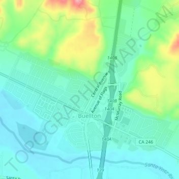
Name: Buellton topographic map, elevation, terrain.
Average elevation: 417 ft
Minimum elevation: 302 ft
Maximum elevation: 738 ft
Santa Barbara County trails, hiking, mountain biking, running and outdoor activities
Other topographic maps
Click on a map to view its topography, its elevation and its terrain.
Mission Canyon
United States > California > Santa Barbara County
The approximate center of Mission Canyon is located at 34°26′59″N 119°42′59″W / 34.44972°N 119.71639°W / 34.44972; -119.71639 (34.449797, -119.716315). Situated along the southern facing slopes of the Santa Ynez Mountains, Mission Canyon measures some 1,122 acres comprising an estimated…
Average elevation: 653 ft
Isla Vista
United States > California > Santa Barbara County
Isla Vista is an unincorporated community and census-designated place (CDP) in Santa Barbara County, California in the United States. As of 2020 census, the community had a population of 15,500. The majority of residents are college students at the University of California, Santa Barbara or at Santa Barbara…
Average elevation: 20 ft