
Corigos topographic map
Interactive map
Click on the map to display elevation.
About this map
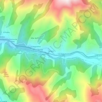
Name: Corigos topographic map, elevation, terrain.
Location: Corigos, Aller, Asturias, 33676, España (43.14515 -5.69516 43.18515 -5.65516)
Average elevation: 2,080 ft
Minimum elevation: 1,086 ft
Maximum elevation: 3,632 ft
Other topographic maps
Click on a map to view its topography, its elevation and its terrain.
Rio Llananzanes
Rio Llananzanes, Aller, Asturias, 33681, España
Average elevation: 3,596 ft
Pico los Aberrugues
Pico los Aberrugues, Aller, Asturias, 33688, España
Average elevation: 4,094 ft