
Felechosa topographic map
Interactive map
Click on the map to display elevation.
About this map
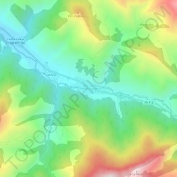
Name: Felechosa topographic map, elevation, terrain.
Location: Felechosa, Aller, Asturias, 33688, España (43.08341 -5.52805 43.12341 -5.48805)
Average elevation: 2,992 ft
Minimum elevation: 1,896 ft
Maximum elevation: 5,003 ft
Other topographic maps
Click on a map to view its topography, its elevation and its terrain.
Rio Llananzanes
Rio Llananzanes, Aller, Asturias, 33681, España
Average elevation: 3,596 ft
Pico los Aberrugues
Pico los Aberrugues, Aller, Asturias, 33688, España
Average elevation: 4,094 ft