
Moore topographic map
Click on the map to display elevation.
About this map
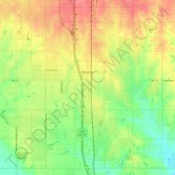
Name: Moore topographic map, elevation, terrain.
Location: Moore, Cleveland County, Oklahoma, 73160, United States (35.29083 -97.52114 35.37060 -97.41496)
Average elevation: 1,224 ft
Minimum elevation: 1,112 ft
Maximum elevation: 1,335 ft
Cleveland County trails, hiking, mountain biking, running and outdoor activities
Other topographic maps
Click on a map to view its topography, its elevation and its terrain.
Southwest Oklahoma City Sludge Lagoon Dam
United States > Oklahoma > Cleveland County > Oklahoma City
Average elevation: 1,142 ft
Sutton Urban Wilderness Park
United States > Oklahoma > Cleveland County > Norman
Average elevation: 1,198 ft
Southwest Oklahoma City Sludge Lagoon Dam
United States > Oklahoma > Cleveland County > Oklahoma City
Average elevation: 1,142 ft