
Naches topographic map
Interactive map
Click on the map to display elevation.
About this map
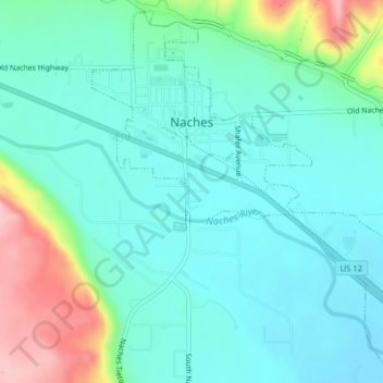
Name: Naches topographic map, elevation, terrain.
Location: Naches, Yakima County, Washington, United States (46.71325 -120.70980 46.73884 -120.67470)
Average elevation: 1,542 ft
Minimum elevation: 1,407 ft
Maximum elevation: 1,972 ft
Other topographic maps
Click on a map to view its topography, its elevation and its terrain.
Selah
United States > Washington > Yakima County
Selah, Yakima County, Washington, 98942, United States
Average elevation: 1,296 ft
Ahtanum
United States > Washington > Yakima County
Ahtanum, Yakima County, Washington, United States
Average elevation: 1,391 ft
Gleed
United States > Washington > Yakima County
Gleed, Yakima County, Washington, United States
Average elevation: 1,391 ft
Goose Prairie
United States > Washington > Yakima County
Goose Prairie, Yakima County, Washington, United States
Average elevation: 3,793 ft
Yakima
United States > Washington > Yakima County > Yakima
Yakima, Yakima County, Washington, 98901, United States
Average elevation: 1,532 ft
Pleasant Hill
United States > Washington > Yakima County > Selah
Pleasant Hill, Selah, Yakima County, Washington, 98942, United States
Average elevation: 1,365 ft
Sunnyside
United States > Washington > Yakima County > Sunnyside > Sunnyside
Sunnyside, Yakima County, Washington, 98944, United States
Average elevation: 784 ft
Grandview
United States > Washington > Yakima County
Grandview, Yakima County, Washington, 98930, United States
Average elevation: 778 ft
Bumping Lake
United States > Washington > Yakima County
Bumping Lake, Yakima County, Washington, United States
Average elevation: 4,055 ft