
Make a donation
Gear up for your next adventure:
As an Amazon Associate, this site earns from qualifying purchases at no extra cost to you.
Deschambault Lake topographic map
Click on the map to display elevation.
Make a donation
Gear up for your next adventure:
As an Amazon Associate, this site earns from qualifying purchases at no extra cost to you.
About this map
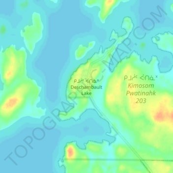
Name: Deschambault Lake topographic map, elevation, terrain.
Location: Deschambault Lake, Division No. 18, Saskatchewan, Canada (54.89056 -103.39846 54.93056 -103.35846)
Average elevation: 1,079 ft
Minimum elevation: 1,056 ft
Maximum elevation: 1,158 ft
Make a donation
Gear up for your next adventure:
As an Amazon Associate, this site earns from qualifying purchases at no extra cost to you.
Other topographic maps
Click on a map to view its topography, its elevation and its terrain.
Delaronde Lake
Canada > Saskatchewan > Division No. 18 > Unorganized Division No. 18
Average elevation: 1,699 ft
Make a donation
Gear up for your next adventure:
As an Amazon Associate, this site earns from qualifying purchases at no extra cost to you.
Churchill River
Canada > Saskatchewan > Division No. 18 > Unorganized Division No. 18
Average elevation: 1,375 ft
Make a donation
Gear up for your next adventure:
As an Amazon Associate, this site earns from qualifying purchases at no extra cost to you.
Make a donation
Gear up for your next adventure:
As an Amazon Associate, this site earns from qualifying purchases at no extra cost to you.
Read Lake
Canada > Saskatchewan > Division No. 18 > Unorganized Division No. 18
Average elevation: 1,253 ft
Athabasca Sand Dunes Provincial Park
Canada > Saskatchewan > Division No. 18
Average elevation: 919 ft
Make a donation
Gear up for your next adventure:
As an Amazon Associate, this site earns from qualifying purchases at no extra cost to you.