Geolocate

Bobbio topographic map

Click on the map to display elevation.

About this map

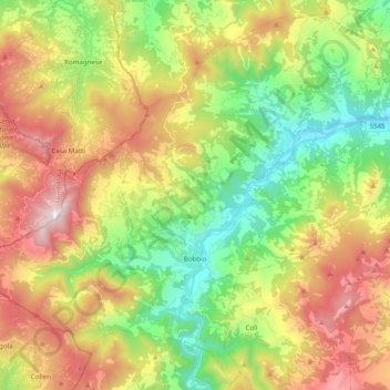
Name: Bobbio topographic map, elevation, terrain.

Location: Bobbio, Piacenza, Emilia-Romagna, 29022, Italy (44.72484 9.28492 44.85741 9.48098)

Average elevation: 2,369 ft

Minimum elevation: 650 ft

Maximum elevation: 4,757 ft

Other topographic maps

Click on a map to view its topography, its elevation and its terrain.

Misano

Italy > Emilia-Romagna > Piacenza > Agazzano

Average elevation: 787 ft

Crocinito

Italy > Emilia-Romagna > Piacenza

Average elevation: 1,854 ft

Bogli

Italy > Emilia-Romagna > Piacenza > Ottone

Average elevation: 3,898 ft

Sariano

Italy > Emilia-Romagna > Piacenza > Gropparello

Average elevation: 873 ft

Fiorano

Italy > Emilia-Romagna > Piacenza > Travo

Average elevation: 932 ft

Capannette di Pej

Italy > Emilia-Romagna > Piacenza > Zerba

Average elevation: 4,304 ft

Dadomo

Italy > Emilia-Romagna > Piacenza > Vernasca

Average elevation: 2,264 ft

Gear up for your next adventure:

😴Insulated Sleeping Pads - Compact and warm pads for high-elevation camping
🛰️Satellite Messengers - Emergency SOS and two-way messaging for off-grid adventures
❄️Traction Cleats - Prevent slips on icy trails during winter hikes
🌡️Handheld Weather Meters - Measure wind, temp, and pressure for safe mountain travel
📡GPS Antenna Upgrade - Enhance GPS reception in remote terrain

As an Amazon Associate, this site earns from qualifying purchases at no extra cost to you.