Geolocate

Laporte topographic map

Click on the map to display elevation.

About this map

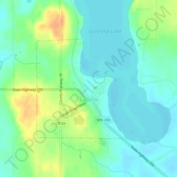
Name: Laporte topographic map, elevation, terrain.

Location: Laporte, Hubbard County, Minnesota, United States (47.20812 -94.76511 47.22331 -94.74469)

Average elevation: 1,345 ft

Minimum elevation: 1,302 ft

Maximum elevation: 1,427 ft

Hubbard County trails, hiking, mountain biking, running and outdoor activities

Other topographic maps

Click on a map to view its topography, its elevation and its terrain.

Badoura

United States > Minnesota > Hubbard County

Average elevation: 1,407 ft

Rosby

United States > Minnesota > Hubbard County

Average elevation: 1,391 ft

Many Arm Lake

United States > Minnesota > Hubbard County

Average elevation: 1,480 ft

Gear up for your next adventure:

🧭Outdoor Navigation Book - Learn advanced navigation skills
🪑Ultralight Camp Chairs - Portable seating for resting after a long day of mapping
📶Vehicle Signal Boosters - Improve reception in rural areas while driving to trailheads
Solar GPS Watches - Advanced multisport watches with built-in topographic maps
🧢Sun Protection Hats - Wide-brimmed and UPF-rated hats for high-altitude sun safety

As an Amazon Associate, this site earns from qualifying purchases at no extra cost to you.