
Make a donation
Gear up for your next adventure:
As an Amazon Associate, this site earns from qualifying purchases at no extra cost to you.
North Barrow topographic map
Click on the map to display elevation.
Make a donation
Gear up for your next adventure:
As an Amazon Associate, this site earns from qualifying purchases at no extra cost to you.
About this map
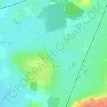
Name: North Barrow topographic map, elevation, terrain.
Location: North Barrow, Somerset, England, United Kingdom (51.05513 -2.58567 51.07741 -2.53914)
Average elevation: 121 ft
Minimum elevation: 75 ft
Maximum elevation: 256 ft
Make a donation
Gear up for your next adventure:
As an Amazon Associate, this site earns from qualifying purchases at no extra cost to you.
Other topographic maps
Click on a map to view its topography, its elevation and its terrain.
Chard
United Kingdom > England > Somerset
Chard is a town and a civil parish in the English county of Somerset. It lies on the A30 road near the Devon and Dorset borders, 15 miles (24 km) south west of Yeovil. The parish has a population of approximately 14,000 and, at an elevation of 121 metres (397 ft), Chard is the southernmost and one of the…
Average elevation: 443 ft
Make a donation
Gear up for your next adventure:
As an Amazon Associate, this site earns from qualifying purchases at no extra cost to you.
Make a donation
Gear up for your next adventure:
As an Amazon Associate, this site earns from qualifying purchases at no extra cost to you.
Halse Combe
United Kingdom > England > Somerset > Somerset West and Taunton > Allerford > Horner
Average elevation: 440 ft
Allerford
United Kingdom > England > Somerset > Somerset West and Taunton > Allerford
Average elevation: 367 ft
Horner Water
United Kingdom > England > Somerset > Somerset West and Taunton > Luccombe
Average elevation: 814 ft
Make a donation
Gear up for your next adventure:
As an Amazon Associate, this site earns from qualifying purchases at no extra cost to you.
Bossington
United Kingdom > England > Somerset > Somerset West and Taunton > Bossington
Average elevation: 226 ft