
Make a donation
Gear up for your next adventure:
As an Amazon Associate, this site earns from qualifying purchases at no extra cost to you.
Cooper Landing topographic map
Click on the map to display elevation.
Make a donation
Gear up for your next adventure:
As an Amazon Associate, this site earns from qualifying purchases at no extra cost to you.
Cooper Landing
Cooper Landing is located in the north-central part of the Kenai Peninsula at 60°29′26″N 149°47′40″W / 60.49056°N 149.79444°W / 60.49056; -149.79444 (60.490529, -149.794519). The center of the community is at the west end of Kenai Lake, where the lake flows into the Kenai River. The CDP extends east up Kenai Lake beyond the mouth of Quartz Creek from the north. To the south the CDP reaches Cooper Lake, and Cooper Creek, the lake's outlet, forms a portion of the CDP's southern border. The CDP reaches west down the Kenai River as far as the mouth of the Russian River, and to the north the CDP extends up the valley of Juneau Creek as far as Trout Lake. Elevations in the CDP range from approximately 330 feet (100 m) above sea level at the mouth of the Russian River, to 436 feet (133 m) at Kenai Lake, to 4,576 feet (1,395 m) at the summit of Cecil Rhode Mountain between Kenai Lake and Cooper Creek.
Make a donation
Gear up for your next adventure:
As an Amazon Associate, this site earns from qualifying purchases at no extra cost to you.
About this map
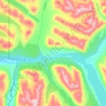
Name: Cooper Landing topographic map, elevation, terrain.
Location: Cooper Landing, Kenai Peninsula, Alaska, United States (60.40322 -150.00004 60.58730 -149.67565)
Average elevation: 1,995 ft
Minimum elevation: 312 ft
Maximum elevation: 4,993 ft
Kenai Peninsula trails, hiking, mountain biking, running and outdoor activities
Make a donation
Gear up for your next adventure:
As an Amazon Associate, this site earns from qualifying purchases at no extra cost to you.
Other topographic maps
Click on a map to view its topography, its elevation and its terrain.
Homer
United States > Alaska > Kenai Peninsula > Homer
Some birds seen during the spring migration and the festival include horned puffins, sandhill cranes, and arctic terns. Arctic Terns are famous for flying the longest distance of any migrating bird. Many of the birds seen during the festival can be identified with the help of published guides that categorize…
Average elevation: 348 ft
Make a donation
Gear up for your next adventure:
As an Amazon Associate, this site earns from qualifying purchases at no extra cost to you.
Make a donation
Gear up for your next adventure:
As an Amazon Associate, this site earns from qualifying purchases at no extra cost to you.
Make a donation
Gear up for your next adventure:
As an Amazon Associate, this site earns from qualifying purchases at no extra cost to you.