
Make a donation
Gear up for your next adventure:
As an Amazon Associate, this site earns from qualifying purchases at no extra cost to you.
Grewingk Glacier topographic map
Click on the map to display elevation.
Make a donation
Gear up for your next adventure:
As an Amazon Associate, this site earns from qualifying purchases at no extra cost to you.
About this map
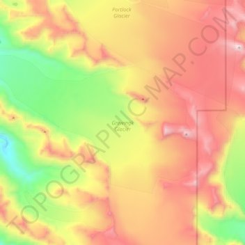
Name: Grewingk Glacier topographic map, elevation, terrain.
Location: Grewingk Glacier, Kenai Peninsula, Alaska, United States (59.53623 -151.07330 59.60633 -150.83325)
Average elevation: 3,376 ft
Minimum elevation: 932 ft
Maximum elevation: 5,768 ft
Kenai Peninsula trails, hiking, mountain biking, running and outdoor activities
Make a donation
Gear up for your next adventure:
As an Amazon Associate, this site earns from qualifying purchases at no extra cost to you.
Other topographic maps
Click on a map to view its topography, its elevation and its terrain.
Make a donation
Gear up for your next adventure:
As an Amazon Associate, this site earns from qualifying purchases at no extra cost to you.
Homer
United States > Alaska > Kenai Peninsula
Many of the birds seen during the festival can be identified with the help of published guides that categorize distinguishable features such as, topography, silhouette, size, and color.
Average elevation: 341 ft
Make a donation
Gear up for your next adventure:
As an Amazon Associate, this site earns from qualifying purchases at no extra cost to you.
Diamond Ridge
United States > Alaska > Kenai Peninsula
The community is named for the high ground, Diamond Ridge, on which it sits. The ridge reaches an elevation of 1,202 feet (366 m) above sea level and is in the southern part of the CDP. Parallel landforms to the north are Crossman Ridge in the center of the CDP and a ridge connecting 1,513-foot (461 m) Ohlson…
Average elevation: 699 ft
Homer
United States > Alaska > Kenai Peninsula > Homer
Some birds seen during the spring migration and the festival include horned puffins, sandhill cranes, and arctic terns. Arctic Terns are famous for flying the longest distance of any migrating bird. Many of the birds seen during the festival can be identified with the help of published guides that categorize…
Average elevation: 348 ft
Make a donation
Gear up for your next adventure:
As an Amazon Associate, this site earns from qualifying purchases at no extra cost to you.
Make a donation
Gear up for your next adventure:
As an Amazon Associate, this site earns from qualifying purchases at no extra cost to you.
Cooper Landing
United States > Alaska > Kenai Peninsula
Cooper Landing is located in the north-central part of the Kenai Peninsula at 60°29′26″N 149°47′40″W / 60.49056°N 149.79444°W / 60.49056; -149.79444 (60.490529, -149.794519). The center of the community is at the west end of Kenai Lake, where the lake flows into the Kenai River. The CDP…
Average elevation: 1,995 ft
Make a donation
Gear up for your next adventure:
As an Amazon Associate, this site earns from qualifying purchases at no extra cost to you.