
Ayaviri topographic map
Interactive map
Click on the map to display elevation.
About this map
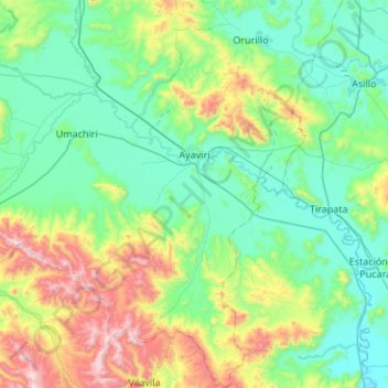
Name: Ayaviri topographic map, elevation, terrain.
Location: Ayaviri, Melgar, Puno, Pérou (-15.19489 -70.77639 -14.67452 -70.43642)
Average elevation: 13,602 ft
Minimum elevation: 12,595 ft
Maximum elevation: 16,991 ft
Other topographic maps
Click on a map to view its topography, its elevation and its terrain.