
Make a donation
Gear up for your next adventure:
As an Amazon Associate, this site earns from qualifying purchases at no extra cost to you.
Westfield topographic map
Click on the map to display elevation.
Make a donation
Gear up for your next adventure:
As an Amazon Associate, this site earns from qualifying purchases at no extra cost to you.
About this map
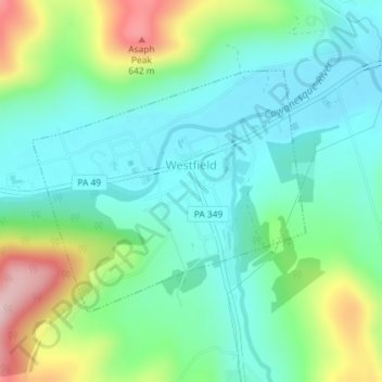
Name: Westfield topographic map, elevation, terrain.
Location: Westfield, Tioga County, Pennsylvania, United States (41.90881 -77.55400 41.92591 -77.52798)
Average elevation: 1,578 ft
Minimum elevation: 1,325 ft
Maximum elevation: 2,215 ft
Tioga County trails, hiking, mountain biking, running and outdoor activities
Make a donation
Gear up for your next adventure:
As an Amazon Associate, this site earns from qualifying purchases at no extra cost to you.
Other topographic maps
Click on a map to view its topography, its elevation and its terrain.
Make a donation
Gear up for your next adventure:
As an Amazon Associate, this site earns from qualifying purchases at no extra cost to you.
Somers Lane
United States > Pennsylvania > Tioga County > Lawrence Township
Average elevation: 1,237 ft
Lambs Creek
United States > Pennsylvania > Tioga County > Richmond Township
Average elevation: 1,493 ft
Make a donation
Gear up for your next adventure:
As an Amazon Associate, this site earns from qualifying purchases at no extra cost to you.