Geolocate

Rettendon Common topographic map

Click on the map to display elevation.

About this map

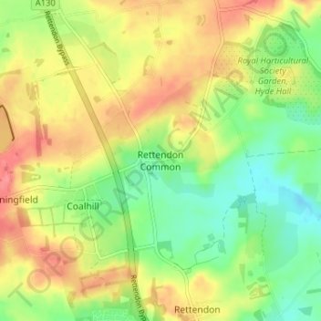
Name: Rettendon Common topographic map, elevation, terrain.

Location: Rettendon Common, Chelmsford, Essex, England, CM3 8EQ, United Kingdom (51.63519 0.53137 51.67519 0.57137)

Average elevation: 125 ft

Minimum elevation: 20 ft

Maximum elevation: 230 ft

Other topographic maps

Click on a map to view its topography, its elevation and its terrain.

Rettendon

United Kingdom > England > Essex > Chelmsford > Rettendon

Average elevation: 85 ft

Broomfield

United Kingdom > England > Essex > Chelmsford

Average elevation: 154 ft

College Wood

United Kingdom > England > Essex > Chelmsford

Average elevation: 138 ft

Roxwell

United Kingdom > England > Essex > Chelmsford > Roxwell

Average elevation: 184 ft

Springfield

United Kingdom > England > Essex > Chelmsford

Average elevation: 138 ft

Sandon

United Kingdom > England > Essex > Chelmsford > Sandon

Average elevation: 135 ft

West Hanningfield

United Kingdom > England > Essex > Chelmsford

Average elevation: 184 ft

Gear up for your next adventure:

Backpacking Tent - Lightweight and durable tent for multi‑day hikes
🧭Hiking Compass - Precision compass for reliable navigation in the wilderness
💧Water Filtration Bottles - Safely drink from streams and lakes while exploring
🔊Portable Camp Speaker - Music and alerts at camp
🧦Merino Wool Socks - Moisture-wicking, blister-preventing socks for long treks

As an Amazon Associate, this site earns from qualifying purchases at no extra cost to you.