Geolocate

Tipolo topographic map

Click on the map to display elevation.

About this map

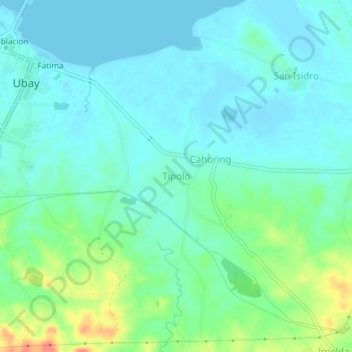
Name: Tipolo topographic map, elevation, terrain.

Location: Tipolo, Bohol, Central Visayas, 6315, Philippines (10.02343 124.47142 10.06343 124.51142)

Average elevation: 46 ft

Minimum elevation: 0 ft

Maximum elevation: 194 ft

Other topographic maps

Click on a map to view its topography, its elevation and its terrain.

Pamilacan Island

Philippines > Bohol > Pamilacan

Average elevation: 7 ft

Maribojoc

Philippines > Bohol

Average elevation: 223 ft

Malinao Dam

Philippines > Bohol > Del Pilar

Average elevation: 499 ft

Tabalong

Philippines > Bohol > Dauis

Average elevation: 62 ft

Tagbilaran

Philippines > Bohol

Average elevation: 82 ft

Bingag

Philippines > Bohol > Dauis

Average elevation: 62 ft

creek

Philippines > Bohol > Duero

Average elevation: 39 ft

Biking

Philippines > Bohol > Dauis

Average elevation: 187 ft

Candijay

Philippines > Bohol

Average elevation: 312 ft

Batas Island

Philippines > Bohol > Batasan

Average elevation: 0 ft

Gear up for your next adventure:

📷Action Camera - Capture your outdoor adventures in HD
🛏️Cold Weather Sleeping Bag - Warm sleeping bag for cold conditions
🗺️Topographic Maps - Detailed topo maps for hiking, exploring and outdoor navigation
🏕️Family Camping Gear - Essentials for group camping trips
🥤Water Filter Bottle - All‑in‑one filter bottle for safe hydration

As an Amazon Associate, this site earns from qualifying purchases at no extra cost to you.