
Make a donation
Gear up for your next adventure:
As an Amazon Associate, this site earns from qualifying purchases at no extra cost to you.
Yecapixtla topographic map
Click on the map to display elevation.
Make a donation
Gear up for your next adventure:
As an Amazon Associate, this site earns from qualifying purchases at no extra cost to you.
Yecapixtla
The area is part of the slopes around the Popocatépetl volcano. The highest elevations are in the north, descending gradually to the south, east, and west. Major elevations include Yoteco (2110 masl), Boyero (1824 masl) and Mirador (1882 masl). There are formations of volcanic rock, including basalt. Surface water consists of runoff from Popocatepetl into streams and small rivers, many of which have formed deep ravines such as the one named Yecapixtla, which begins in the State of Mexico and passes through Zahuatlán and Mexquemeca. before emptying into the Cuautla River. Other streams include Arcos de Ortiz, Malpaso or La Cuera and Del Negro. Other named ravines in the territory include Xococotla, Atlamaxa, Las Animas, Tepanche, Xalpa, Tamalera, and Remudadero. There are also a number of freshwater springs such as Chirimoyo, Las Pilas, La Tenería, La Mora, and Tepetlapa. In general, the climate is warm and humid with rains falling principally from June to October. Average temperature is 19.6 °C, and annual rainfall is between 800 and 1000mm. There is little difference among the seasons in temperature. Overall, the north tends to be somewhat cooler than the south due to altitude. Much of the municipality is covered in pine and holm oak forest, with some other species such as amate (a type of fig) tree, casahuates and guamuchiles. Most other vegetation is deciduous. Most of the area's wildlife has been extinguished with only various insects and reptiles to be found wild.
Make a donation
Gear up for your next adventure:
As an Amazon Associate, this site earns from qualifying purchases at no extra cost to you.
About this map
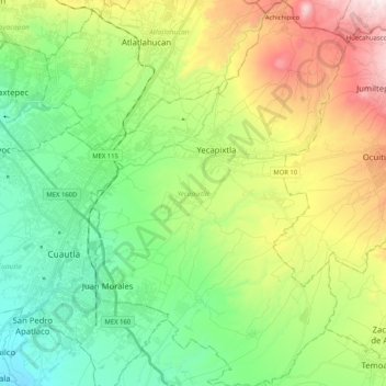
Name: Yecapixtla topographic map, elevation, terrain.
Location: Yecapixtla, Morelos, Mexico (18.76227 -98.92913 18.95671 -98.79208)
Average elevation: 5,174 ft
Minimum elevation: 3,937 ft
Maximum elevation: 7,592 ft
Make a donation
Gear up for your next adventure:
As an Amazon Associate, this site earns from qualifying purchases at no extra cost to you.
Other topographic maps
Click on a map to view its topography, its elevation and its terrain.
Cuernavaca
Mexico > Morelos > Cuernavaca
The city is located in a tropical region, but its temperature is fairly constant at 21–26 °C (70–79 °F). It is located on the southern slope of the Sierra de Chichinautzin mountains. In the morning, warm air flows up the mountains from the valley below and in the late afternoon, cooler air flows down…
Average elevation: 5,978 ft
Make a donation
Gear up for your next adventure:
As an Amazon Associate, this site earns from qualifying purchases at no extra cost to you.
Make a donation
Gear up for your next adventure:
As an Amazon Associate, this site earns from qualifying purchases at no extra cost to you.