Geolocate

Bow topographic map

Click on the map to display elevation.

About this map

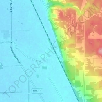
Name: Bow topographic map, elevation, terrain.

Location: Bow, Skagit County, Washington, 98232, United States (48.54177 -122.41822 48.58177 -122.37822)

Average elevation: 95 ft

Minimum elevation: -3 ft

Maximum elevation: 374 ft

Skagit County trails, hiking, mountain biking, running and outdoor activities

Other topographic maps

Click on a map to view its topography, its elevation and its terrain.

Hope Island

United States > Washington > Skagit County

Average elevation: 13 ft

Hat Island

United States > Washington > Skagit County

Average elevation: 10 ft

Lake Cavanaugh

United States > Washington > Skagit County

Average elevation: 1,457 ft

Alger

United States > Washington > Skagit County

Average elevation: 427 ft

Dog Woods

United States > Washington > Skagit County

Average elevation: 79 ft

Gear up for your next adventure:

GPS Sports Watch - GPS watch for running, hiking and training
🥾Women's Hiking Boots - Top-rated trail boots with ankle support and superior grip
🧭Compass with Lanyard - Easy‑carry compass for navigation
📻Weather Alert Radios - Stay informed of storm risks while off-the-grid
📚USA Hiking Guide Books - Top trail guides and map books

As an Amazon Associate, this site earns from qualifying purchases at no extra cost to you.