Geolocate

Hat Island topographic map

Click on the map to display elevation.

About this map

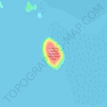
Name: Hat Island topographic map, elevation, terrain.

Location: Hat Island, Skagit County, Washington, United States (48.51978 -122.55248 48.52855 -122.54349)

Average elevation: 10 ft

Minimum elevation: 0 ft

Maximum elevation: 308 ft

Skagit County trails, hiking, mountain biking, running and outdoor activities

Other topographic maps

Click on a map to view its topography, its elevation and its terrain.

Hoogdal

United States > Washington > Skagit County

Average elevation: 305 ft

Anacortes

United States > Washington > Skagit County > Anacortes > Anacortes

Average elevation: 121 ft

Mount Erie

United States > Washington > Skagit County > Anacortes

Average elevation: 420 ft

Dewey

United States > Washington > Skagit County > Anacortes

Average elevation: 115 ft

Dog Woods

United States > Washington > Skagit County

Average elevation: 79 ft

Conway

United States > Washington > Skagit County

Average elevation: 23 ft

Belfast

United States > Washington > Skagit County

Average elevation: 220 ft

Forbidden Peak

United States > Washington > Skagit County

Average elevation: 6,906 ft

Bow

United States > Washington > Skagit County

Average elevation: 95 ft

Gear up for your next adventure:

🩳Quick‑Dry Hiking Shorts - Comfortable and quick‑dry shorts for summer hiking
🛡️Bear Spray Outdoor - Protection in bear country hikes
🥄Camping Utensil Set - Lightweight utensils for outdoor meals
🥘Titanium Cookware - Durable, featherlight pots and pans for backpacking
🛌Ultralight Sleeping Bags - Compact down bags for cold nights in the wilderness

As an Amazon Associate, this site earns from qualifying purchases at no extra cost to you.