Geolocate

Hope Island topographic map

Click on the map to display elevation.

About this map

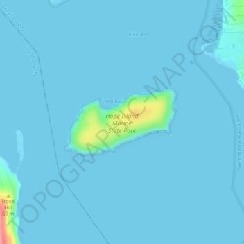
Name: Hope Island topographic map, elevation, terrain.

Location: Hope Island, Skagit County, Washington, United States (48.39507 -122.57862 48.40254 -122.55969)

Average elevation: 13 ft

Minimum elevation: -7 ft

Maximum elevation: 305 ft

Skagit County trails, hiking, mountain biking, running and outdoor activities

Other topographic maps

Click on a map to view its topography, its elevation and its terrain.

Hoogdal

United States > Washington > Skagit County

Average elevation: 305 ft

Dewey

United States > Washington > Skagit County > Anacortes

Average elevation: 115 ft

Dog Woods

United States > Washington > Skagit County

Average elevation: 79 ft

Conway

United States > Washington > Skagit County

Average elevation: 23 ft

Belfast

United States > Washington > Skagit County

Average elevation: 220 ft

Anacortes

United States > Washington > Skagit County > Anacortes > Anacortes

Average elevation: 121 ft

Mount Erie

United States > Washington > Skagit County > Anacortes

Average elevation: 420 ft

Bow

United States > Washington > Skagit County

Average elevation: 95 ft

Forbidden Peak

United States > Washington > Skagit County

Average elevation: 6,906 ft

Gear up for your next adventure:

🔌USB Car Charger - Car charger for on‑the‑go power needs
🔦Compact Flashlight - Reliable flashlight for emergencies
🚑Emergency Bivvies - Heat-reflective sleeping bags for survival situations
🗃️Trail First Aid Kit - Essential kit for outdoor injuries and emergencies
👓Polarized Sunglasses - Outdoor sunglasses for glare reduction

As an Amazon Associate, this site earns from qualifying purchases at no extra cost to you.